Currently it only shows your basic business info. Start adding relevant business details such as description, images and products or services to gain your customers attention by using Boost 360
android app
/
iOS App/ web portal.
{
"products": [
{
"_id": "65cf1a9a6f500018087d604e",
"fptag": "SBENTERPRISESTRADINGPUNE",
"merchantname": null,
"customwidgets": null,
"externalsourceid": null,
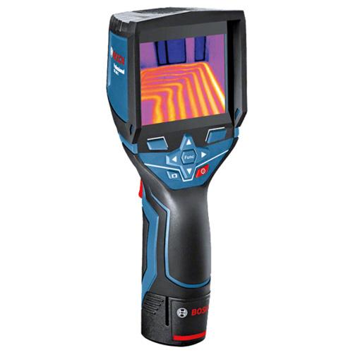
"name": "Bosch GTC 400 C Professional thermal camera",
"description": "The Bosch GTC 400 C Professional thermal camera is designed to provide high-quality thermal imaging for various applications. Here are some key features and benefits:\nHigh-Quality Thermal Images: The thermal camera boasts a 160 x 120 pixel sensor, resulting in 19,200 measuring points. This high resolution allows for detailed and accurate thermal imaging, making it easier to visualize temperature differences in the working environment.\nTemperature Range and Accuracy: The GTC 400 C has a broad temperature range, allowing it to measure temperatures between -10°C and +400°C. The device provides an accuracy of ±3°C, ensuring reliable and precise temperature readings in various conditions.\nData Storage and Reference: With the ability to save up to 500 visual and thermal images, the device enables users to document measurements for later reference. This feature is valuable for creating records, analyzing trends, and maintaining a history of thermal conditions.\nEasy Data Transfer and Analysis: The Measuring Master app facilitates quick data exchange and documentation of measurements. Additionally, the PC software allows users to edit thermal images and create detailed reports. This feature enhances the overall usability of the thermal camera in professional settings.\nUser-Friendly Interface: The thermal camera is designed with ease of use in mind. The interface is user-friendly, and important functions can be accessed with just one click. The picture-in-picture function is a useful feature that aids in locating measurements efficiently.\nVersatility: The wide working temperature range and high image quality make the GTC 400 C suitable for a variety of applications, from industrial and construction settings to maintenance and troubleshooting tasks.\nApplication Support: The device is supported by the Measuring Master app, providing additional functionality and connectivity options for seamless integration into various workflows.\nOverall, the Bosch GTC 400 C Professional thermal camera appears to be a versatile and reliable tool for professionals who require accurate thermal imaging in their work.\n\nThe Bosch GTC 400 C Professional thermal camera is well-suited for a wide range of applications, including but not limited to:\nElectrical Applications:\nQuickly and effectively check cable connections for anomalies or overheating.Inspect cabinets and electrical components to identify potential issues.Detect abnormal temperature patterns that may indicate electrical problems.HVAC (Heating, Ventilation, and Air Conditioning):\nCheck underfloor heating systems to ensure even heat distribution.Locate leaks in HVAC systems by identifying temperature variations.Inspect radiators for proper functioning and identify any blockages or malfunctions.Window Installation:\nSearch for faulty insulation in windows and doors.Identify thermal bridges that can contribute to energy inefficiency.Detect leaks and water penetration around windows and doors.Automotive:\nScan heating and cooling systems to identify temperature irregularities.Inspect fuse boxes for overheating or electrical issues.Check coolant pipes and radiators for leaks or blockages.Inspect catalytic converters for proper functioning.In each of these applications, the thermal camera's ability to visualize temperature differences provides a valuable tool for preventive maintenance, troubleshooting, and quality control. It allows professionals to identify potential problems before they lead to more significant issues, improving overall efficiency and safety in various industries. The device's wide temperature range, high image quality, and user-friendly interface make it a versatile tool for professionals in electrical, HVAC, construction, automotive, and related fields.",
"price": 72000.0,
"discountamount": 0.0,
"currencycode": "INR",
"priority": 1000000,
"isfreeshipmentavailable": false,
"shipmentduration": 7,
"_keywords": [
"ease",
"mind",
"10°C",
"±3°C",
"Scan",
"users",
"doors",
"leaks",
"safety",
"device",
"trends",
"+400°C",
"Search",
"variety",
"records",
"history",
"windows",
"cabinets",
"Analysis",
"benefits",
"Accuracy",
"anomalies",
"blockages",
"one click",
"500 visual",
"wide range",
"industrial",
"fuse boxes",
"Automotive",
"Versatility",
"overheating",
"Ventilation",
"PC software",
"temperatures",
"key features",
"malfunctions",
"measurements",
"Data Storage",
"HVAC systems",
"reliable tool",
"coolant pipes",
"valuable tool",
"The GTC 400 C",
"professionals",
"documentation",
"versatile tool",
"related fields",
"useful feature",
"later reference",
"thermal bridges",
"high resolution",
"quality control",
"cooling systems",
"potential issues",
"Air Conditioning",
"picture function",
"detailed reports",
"Inspect radiators",
"water penetration",
"electrical issues",
"overall usability",
"heat distribution",
"various workflows",
"faulty insulation",
"cable connections",
"various industries",
"overall efficiency",
"proper functioning",
"thermal conditions",
"significant issues",
"various conditions",
"potential problems",
"Easy Data Transfer",
"high image quality",
"quick data exchange",
"working environment",
"Application Support",
"important functions",
"energy inefficiency",
"Window Installation",
"electrical problems",
"various applications",
"seamless integration",
"connectivity options",
"catalytic converters",
"construction settings",
"troubleshooting tasks",
"professional settings",
"electrical components",
"preventive maintenance",
"wide temperature range",
"temperature variations",
"160 x 120 pixel sensor",
"temperature differences",
"19,200 measuring points",
"Electrical Applications",
"broad temperature range",
"User-Friendly Interface",
"The Measuring Master app",
"additional functionality",
"accurate thermal imaging",
"temperature irregularities",
"underfloor heating systems",
"High-Quality Thermal Images",
"precise temperature readings",
"high-quality thermal imaging",
"abnormal temperature patterns",
"wide working temperature range",
"The Bosch GTC 400 C Professional thermal camera"
],
"isarchived": false,
"isavailable": true,
"applicationid": null,
"productindex": 235,
"imageuri": "https://productimages.withfloats.com/actual/65cf1a9e1f63cf9c49f7de00.jpg",
"tileimageuri": "https://productimages.withfloats.com/tile/65cf1a9e1f63cf9c49f7de00.jpg",
"images": null,
"totalqueries": 0,
"gpid": null,
"groupproductid": null,
"createdon": "2024-02-16T08:19:38.327Z",
"updatedon": "2024-02-16T08:19:38.327Z",
"buyonlinelink": null,
"producturl": "http://WWW.SURVEYEQUIPMENT.IN/products/bosch-gtc-400-c-professional-thermal-camera/235",
"availableunits": -1.0,
"iscodavailable": false,
"isprepaidonlineavailable": false,
"maxcodorders": 0,
"maxprepaidonlineorders": 0,
"uniquepaymenturl": null,
"brandname": "BOSCH ",
"category": "ThermalCamera",
"tags": null,
"variants": false,
"keyspecification": null,
"otherspecifications": null,
"pickupaddressreferenceid": "",
"paymenttype": "None",
"producttype": "products",
"hsncode": null,
"gstslab": 0.0,
"isnotforsale": false
},
{
"_id": "62aaf9819592b5000167ad96",
"fptag": "SBENTERPRISESTRADINGPUNE",
"merchantname": null,
"customwidgets": null,
"externalsourceid": null,
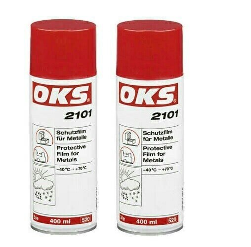
"name": "OKS 500ml Anti-Corrosion Wax Coating Spray Protective Film for Metals, 2101",
"description": "OKS 2101 – Protective Film for Metals, SprayDry and clean protective film fast to handling on a wax basis for metals that can be removed easily and protects against corrosion reliably up to two years.\nAreas of applicationPreservation of bare metal surfaces of all kinds, which are stored for longer periods and are subject to effects of weathering (tropics, ocean, industrial atmosphere)Ideal on-call and storage protection for spare parts with possibility of direction installation\nAdvantages and benefitsHighly effective due to good film-forming propertiesOutstanding corrosion and oxidation protectionNo degreasing prior to commissioning required, as compatible with all lubricantsWaterproof and resistant to weatheringSuitable for all climate zonesNo surface discolouration\nTechnical specificationsOperating temperature: -40 °C → +70 °CSalt spray test: 1,000 h with 50 µm layer thicknessLayer thickness: approx. 10 µm for one-time application\n\nApplications\nFor optimum effect, clean the surfaces. Best way is to clean mechanically first and then with OKS 2610/OKS 2611 universal cleaner. The surfaces must be bright metal and dry. Stir OKS 2100 thoroughly before use. Apply in an evenly thin film to the prepared surfaces, preferably by spraying or dipping, in individual cases also by brush. Shake OKS 2101 well and spray on evenly. Avoid local excesses. Drying times as specified in the following technical data.",
"price": 0.0,
"discountamount": 0.0,
"currencycode": "INR",
"priority": 1000000,
"isfreeshipmentavailable": false,
"shipmentduration": 7,
"_keywords": [
"use",
"10 µ",
"40 °",
"call",
"brush",
"Areas",
"kinds",
"ocean",
"Metals",
"effects",
"1,000 h",
"tropics",
"SprayDry",
"Best way",
"wax basis",
"thin film",
"two years",
"weathering",
"Advantages",
"spare parts",
"possibility",
"bright metal",
"Drying times",
"benefitsHighly",
"local excesses",
"optimum effect",
"longer periods",
"climate zonesNo",
"individual cases",
"storage protection",
"bare metal surfaces",
"lubricantsWaterproof",
"industrial atmosphere",
"+70 °CSalt spray test",
"clean protective film",
"surface discolouration",
"oxidation protectionNo",
"direction installation",
"applicationPreservation",
"following technical data",
"one-time application Applications",
"OKS 2610/OKS 2611 universal cleaner",
"50 µm layer thicknessLayer thickness",
"Technical specificationsOperating temperature",
"good film-forming propertiesOutstanding corrosion",
"OKS 500ml Anti-Corrosion Wax Coating Spray Protective Film"
],
"isarchived": false,
"isavailable": true,
"applicationid": null,
"productindex": 220,
"imageuri": "https://productimages.withfloats.com/actual/62aaf981b2387900016594dc.jpg",
"tileimageuri": "https://productimages.withfloats.com/tile/62aaf981b2387900016594dc.jpg",
"images": null,
"totalqueries": 0,
"gpid": null,
"groupproductid": null,
"createdon": "2022-06-16T09:36:01.513Z",
"updatedon": "2022-06-16T09:36:01.513Z",
"buyonlinelink": null,
"producturl": "http://WWW.SURVEYEQUIPMENT.IN/products/oks-500ml-anti-corrosion-wax-coating-spray-protective-film-for-metals-2101/220",
"availableunits": -1.0,
"iscodavailable": false,
"isprepaidonlineavailable": false,
"maxcodorders": 0,
"maxprepaidonlineorders": 0,
"uniquepaymenturl": null,
"brandname": "OKS",
"category": "CRCSPRAY",
"tags": null,
"variants": false,
"keyspecification": null,
"otherspecifications": null,
"pickupaddressreferenceid": "",
"paymenttype": "None",
"producttype": "products",
"hsncode": null,
"gstslab": 0.0,
"isnotforsale": false
},
{
"_id": "60e1a313e49d1200012fbdc3",
"fptag": "SBENTERPRISESTRADINGPUNE",
"merchantname": null,
"customwidgets": null,
"externalsourceid": null,
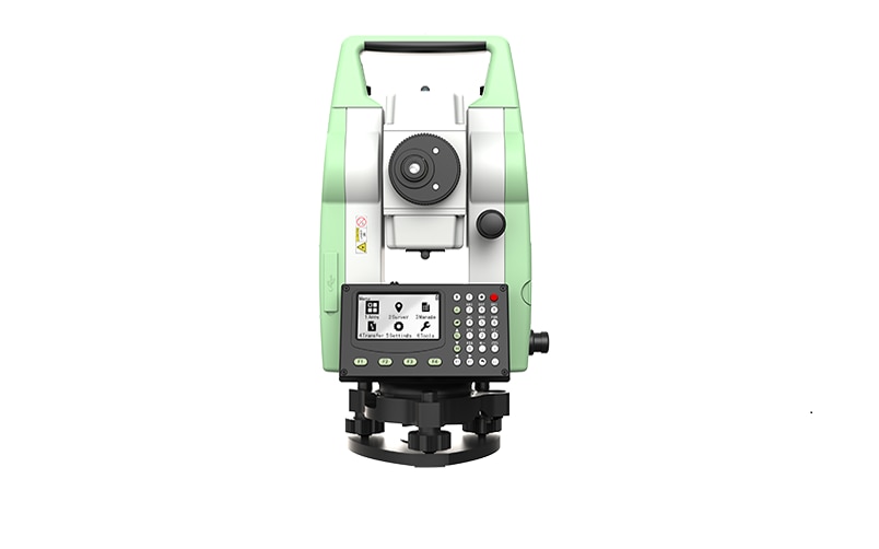
"name": "Leica TS01 Manual Total Stations ",
"description": "Leica TS01: The entry to Leica Geosystems' Total Stations\nLeica TS01 empowers you to carry out measurement tasks with ease and simplicity.\n\nThe Leica TS01 total station empowers you to carry out measurement tasks with ease and simplicity. The TS01 is an entry-level manual total station, created to help you master surveying, layout and mapping projects. It will prove itself in the field and immediately become a valuable member of your team.\n\nBuying a Leica TS01 is a smart decision as it represents a business-smart entry into Leica Geosystems world. You and your surveying crew members will be ready for new projects in no time.\n\nEnjoy the benefits of a 500 m non-prism range and 3,000 m prism range, always combined with accuracy and measurement speed, which increases your productivity. With built-in sensors like an electronic dual axis compensator, a laser plummet, onboard field software and short keys for quick menu access you'll have a fast instrument setup and fast measurements.\n\nWith the Leica TS01 total station you get your all-in-on package as it comes with Leica Geosystems accessories, such as a long-operating battery, a charger and a tribrach tested to reliably fulfil the requirements – when every detail counts.\n\n\nFirst class after sales service and support\n\nLeica Geosystems's highly qualified after-sales service and support network will help you managing any issue to continue work quickly.\nBe it maintenance work, in any of our local service workshops, or getting a question answered from local support, both are part of Leica Geosystems's active customer care.\n\n\nStart-up into business easily\n\n\n\nLeica Geosystems' TS01 will get your trusted partner in managing survey, layout and mapping projects with ease and simplicity.\nPowerful built-in sensors, as well as intuitive field software, empower you to complete tasks without any delay.\n",
"price": 0.0,
"discountamount": 0.0,
"currencycode": "INR",
"priority": 1000000,
"isfreeshipmentavailable": false,
"shipmentduration": 7,
"_keywords": null,
"isarchived": false,
"isavailable": true,
"applicationid": null,
"productindex": 200,
"imageuri": "https://productimages.withfloats.com/actual/60e1a315eef7850001dd7f3e.png",
"tileimageuri": "https://productimages.withfloats.com/tile/60e1a315eef7850001dd7f3e.png",
"images": null,
"totalqueries": 0,
"gpid": null,
"groupproductid": null,
"createdon": "2021-07-04T12:01:23.298Z",
"updatedon": "2021-07-04T12:01:23.298Z",
"buyonlinelink": null,
"producturl": "http://WWW.SURVEYEQUIPMENT.IN//leica-ts01-manual-total-stations-/200",
"availableunits": -1.0,
"iscodavailable": false,
"isprepaidonlineavailable": false,
"maxcodorders": 0,
"maxprepaidonlineorders": 0,
"uniquepaymenturl": null,
"brandname": "Leica Geosystems",
"category": "Leica Total Station in India ",
"tags": [
"Leica Total Station in India",
"TOTALSTATIONS",
"Robotic Total Station",
"leicatotalstationsindia",
"robotictotalstationpune",
"robotictotalstations",
"leicatotalstationsindia",
"leicatotalstationoune",
"leicageosystems",
"Geographical Survey",
"GNSS/GPS Survey Equipment - Surveying Equipment fr"
],
"variants": false,
"keyspecification": null,
"otherspecifications": null,
"pickupaddressreferenceid": "",
"paymenttype": "None",
"producttype": "products",
"hsncode": null,
"gstslab": 0.0,
"isnotforsale": false
},
{
"_id": "5b6b3a9ed682be0552aefdd6",
"fptag": "SBENTERPRISESTRADINGPUNE",
"merchantname": null,
"customwidgets": null,
"externalsourceid": null,
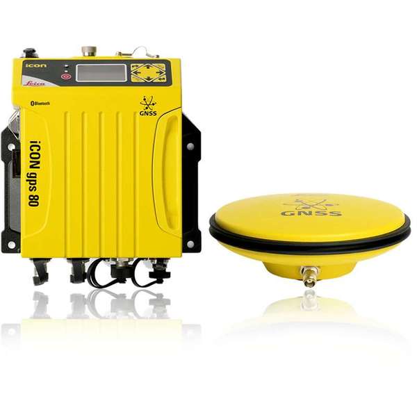
"name": "Leica iCON gps 80",
"description": "Leica iCON gps 80\nThe Leica iCON gps 80 GNSS machine receiver takes machine control to the next level.\nThe iCG80 GNSS receiver in combination with CGA 60 GNSS antenna increases the performance of your iCON machine control solution, allowing you to work more productively than ever before.\n\nIncrease dozer, excavator, drilling, excavator, wheel loader, grader and paver machine uptime. Enjoy the benefits from reliable, fast 3D positioning and productive operation via a high performance machine control system.\n\nKey benefits at a glance\nSensor integration with the machine system increases automatic handling, ease of use and work speed\nIncreased productivity and performance with all system elements fitting together\nCAN bus protocol specifically designed and created for GNSS machine control, providing reliable communication and increased uptime\nBuilt in modem and removable radios for flexible communication\nxRTK provides machine guidance and increases productivity in demanding environments\nLeica iCON telematics allows remote access to the machine computer fast data transfer and support\n\nUltimate performance for machine applications\nThe iCON GPS 80 GNSS machine receiver raises the performance of the machine control system to ensures maximum uptime and enabling applications to be done more quickly without compromising on quality.\n\n",
"price": 0.0,
"discountamount": 0.0,
"currencycode": "INR",
"priority": 1000000,
"isfreeshipmentavailable": false,
"shipmentduration": 7,
"_keywords": [
"machine guidance",
"machine computer",
"iCG80 GNSS receiver",
"GNSS machine control",
"paver machine uptime",
"machine control system",
"increases productivity",
"reliable communication",
"iCON machine control solution",
"CGA 60 GNSS antenna increases",
"high performance machine control",
"machine system increases automatic",
"Leica iCON gps 80 GNSS machine receiver"
],
"isarchived": false,
"isavailable": true,
"applicationid": null,
"productindex": 98,
"imageuri": "https://productimages.withfloats.com/actual/5b486344f599f80511fd98b1.jpg",
"tileimageuri": "https://productimages.withfloats.com/tile/5b486344f599f80511fd98b1.jpg",
"images": null,
"totalqueries": 0,
"gpid": null,
"groupproductid": null,
"createdon": "2018-07-13T08:31:00.378Z",
"updatedon": "2018-08-08T18:46:54.336Z",
"buyonlinelink": null,
"producturl": "http://WWW.SURVEYEQUIPMENT.IN//leica-icon-gps-80/98",
"availableunits": -1.0,
"iscodavailable": true,
"isprepaidonlineavailable": false,
"maxcodorders": 0,
"maxprepaidonlineorders": 0,
"uniquepaymenturl": null,
"brandname": null,
"category": "Topographical Survey",
"tags": [
"Topographical Survey",
"Transmission Line Survey",
"Survey Equipments",
"Geographical Survey",
"Road Survey"
],
"variants": false,
"keyspecification": null,
"otherspecifications": null,
"pickupaddressreferenceid": "5d08ebb3edf0e25c3b8da5d0",
"paymenttype": "AssuredPurchase",
"producttype": "products",
"hsncode": null,
"gstslab": 0.0,
"isnotforsale": false
},
{
"_id": "5b6b3a9ed682be0552aefd47",
"fptag": "SBENTERPRISESTRADINGPUNE",
"merchantname": null,
"customwidgets": null,
"externalsourceid": null,
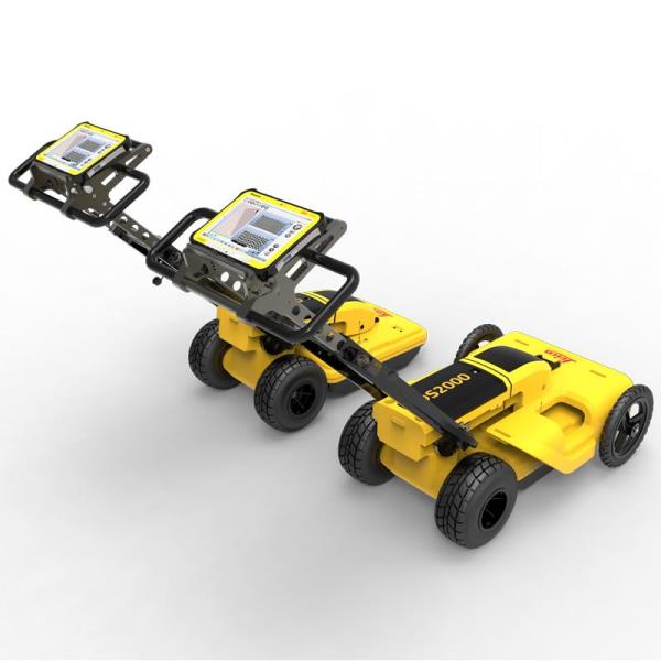
"name": "Leica DS2000 Utility Detection Radar",
"description": "Leica DS2000 Utility Detection Radar\nUncovering safer, faster, more\n\nThere’s a lot going on underground that you need to know about before you ever start to dig. The Leica DS2000 Utility Detection Radar finds all potential threats, including non-conductive pipes and fibre optics, increasing safety by lowering the risk of accidently hitting underground assets.\n\nIncrease safety, speed up work and lower asset management costs with the ability to prevent hazardous outages and collect more information. The DS2000 betters your business by making it safer, faster and more efficient.\n\nKey benefits\nIncrease safety when the DS2000 identifies all potential threats\nGet to assets and recover quicker from outages when you know exactly where underground utility assets are located\nDual-frequency antenna to detect deep and shallow targets simultaneously\nEasily collect and understand data with the DS2000’s simple and intuitive software and data storage\nSimple data storage and export to continue working on the post-processing at the office\nEffortlessly maneuver around the most challenging sites with the DS2000’s advanced ergonomics\nExpert knowledge of Leica Geosystems with more than 270 service centres worldwide\nPROTECT by Leica Geosystems - the strongest warranty in the market\n\nDetection and underground mapping solution\nCombined with the powerful and rugged Leica CT2000 field tablet, the GG04 or the GPS60 smart antenna, and the DIGICAT intelligent cable locators and DIGITEX transmitters, the DS2000 is part of the complete Leica Geosystems detection and underground mapping solution that will enhance your business by making it faster and more efficient. With DX Office Vision post processing software, convert radar data to CAD file in an uncomplicated way.\n\nStart today\nContact your Leica Geosystems distribution partner for more information on the Leica DS2000 and other detection solutions.",
"price": 0.0,
"discountamount": 0.0,
"currencycode": "INR",
"priority": 1000000,
"isfreeshipmentavailable": false,
"shipmentduration": 7,
"_keywords": [
"DS2000 betters",
"convert radar data",
"intuitive software",
"GPS60 smart antenna",
"detection solutions",
"DIGITEX transmitters",
"asset management costs",
"Leica CT2000 field tablet",
"underground utility assets",
"DIGICAT intelligent cable locators",
"complete Leica Geosystems detection",
"Leica DS2000 Utility Detection Radar",
"Leica Geosystems distribution partner",
"DX Office Vision post processing software"
],
"isarchived": false,
"isavailable": true,
"applicationid": null,
"productindex": 94,
"imageuri": "https://productimages.withfloats.com/actual/5b45a66fd4575c0f14706fc4.jpg",
"tileimageuri": "https://productimages.withfloats.com/tile/5b45a66fd4575c0f14706fc4.jpg",
"images": null,
"totalqueries": 0,
"gpid": null,
"groupproductid": null,
"createdon": "2018-07-11T06:40:39.103Z",
"updatedon": "2018-08-08T18:46:54.113Z",
"buyonlinelink": null,
"producturl": "http://WWW.SURVEYEQUIPMENT.IN/products/leica-ds2000-utility-detection-radar/94",
"availableunits": -1.0,
"iscodavailable": true,
"isprepaidonlineavailable": false,
"maxcodorders": 0,
"maxprepaidonlineorders": 0,
"uniquepaymenturl": null,
"brandname": null,
"category": "GPR Ground Penetrating Radar",
"tags": [
"GPR Ground Penetrating Radar",
"| GPR Ground Penetrating Radar Survey Equipment Di"
],
"variants": false,
"keyspecification": null,
"otherspecifications": null,
"pickupaddressreferenceid": "5d08ebb3edf0e25c3b8da5d0",
"paymenttype": "AssuredPurchase",
"producttype": "products",
"hsncode": null,
"gstslab": 0.0,
"isnotforsale": false
},
{
"_id": "5b6b3a9dd682be0552aefc94",
"fptag": "SBENTERPRISESTRADINGPUNE",
"merchantname": null,
"customwidgets": null,
"externalsourceid": null,
"name": "Leica LOGiCAT VU Management & Monitoring System",
"description": "Leica LOGiCAT VU Management & Monitoring System\nAnalyse data to reduce utility strikes\n\nBy deploying Leica Digicat cable locators, utility strike rates have reduced dramatically. Now, with the introduction of Leica LOGiCAT VU software, cable locators can be managed and monitored centrally.\nData analysis helps fleet managers to improve cable locator usage and effectiveness during the excavation, increases attention to site safety initiative and enhances product familiarisation training and operator behaviour.\n\nWhat is Leica LOGiCAT VU?\nLeica LOGiCAT VU is a management and monitoring system for analysing data from cable locators.\nCable locators are used to identifying the location of buried utilities; the data enables instruments to record GPS coordinates alongside logged instrument data.\nLeica LOGiCAT VU helps plant, fleet and site managers to evaluate and analyse the data from one or more cable locators.\nThe system gives fleet managers a “view” of how the survey was conducted and if it has been undertaken to best practice. The locator positions can be mapped and presented through Google maps, highlighting the path of the survey.\n\nKey benefits\n\nGreater insight if best practice has been followed\nUsing just the cable locator on its own you could miss 45 up to 50% of dormant utilities which hold the potential of fatal injury. The Fleet Manager can evaluate the Leica LOGiCAT VU data and see how and if the Operator has thoroughly undertaken a site investigate, in all modes and with correct accessories, ensuring adherence to best practice.\n\nData visualisation on satellite images to support interpretation\nGPS enables cable locator to record their coordinates alongside usage data. Leica LOGiCAT VU displays field data overlaid on digital map and images, showing where the operator has undertaken the survey to support post-survey evaluation.Clarity for post utility strike evaluation. \n\nClarity for post utility strike evaluation\nIn the event of a utility strike, the incident report can be produced simply and provide a comprehensive and clear view of instruments usage leading up to the incident. Within the report, colours indicate the survey quality, Red/Poor and Green/Good.\n\nData export to GIS and BIM System\nThe instruments data can be exported to a third party GIS and BIM software enhancing knowledge about subsurface utilities for future excavation activities. ",
"price": 0.0,
"discountamount": 0.0,
"currencycode": "INR",
"priority": 1000000,
"isfreeshipmentavailable": false,
"shipmentduration": 7,
"_keywords": [
"instruments data",
"cable locator usage",
"alongside usage data",
"utility strike rates",
"subsurface utilities",
"Leica LOGiCAT VU data",
"enables cable locator",
"site safety initiative",
"data enables instruments",
"Leica LOGiCAT VU software",
"Leica LOGiCAT VU Management",
"post utility strike evaluation",
"deploying Leica Digicat cable locators",
"enhances product familiarisation training"
],
"isarchived": false,
"isavailable": true,
"applicationid": null,
"productindex": 88,
"imageuri": "https://productimages.withfloats.com/actual/5b45a062d3d93d01c4f0ed4e.jpg",
"tileimageuri": "https://productimages.withfloats.com/tile/5b45a062d3d93d01c4f0ed4e.jpg",
"images": null,
"totalqueries": 0,
"gpid": null,
"groupproductid": null,
"createdon": "2018-07-11T06:15:05.058Z",
"updatedon": "2018-08-08T18:46:53.924Z",
"buyonlinelink": null,
"producturl": "http://WWW.SURVEYEQUIPMENT.IN/products/leica-logicat-vu-management-monitoring-system/88",
"availableunits": -1.0,
"iscodavailable": true,
"isprepaidonlineavailable": false,
"maxcodorders": 0,
"maxprepaidonlineorders": 0,
"uniquepaymenturl": null,
"brandname": null,
"category": null,
"tags": null,
"variants": false,
"keyspecification": null,
"otherspecifications": null,
"pickupaddressreferenceid": "5d08ebb3edf0e25c3b8da5d0",
"paymenttype": "AssuredPurchase",
"producttype": "products",
"hsncode": null,
"gstslab": 0.0,
"isnotforsale": false
},
{
"_id": "5b6b3a9dd682be0552aefcbd",
"fptag": "SBENTERPRISESTRADINGPUNE",
"merchantname": null,
"customwidgets": null,
"externalsourceid": null,
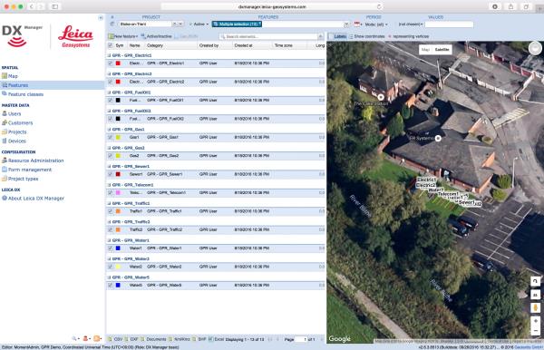
"name": "Leica DX Manager Mapping",
"description": "Leica DX Manager Mapping\nOne central dashboard for all the Leica Geosystems Detection solutions\n\nLeica DX Manager is the only enterprise grade utility mapping solution on the market. A unique cloud-powered solution that delivers unparalleled performance. Manage projects, tasks and spatial data from one central dashboard for all the Leica Geosystems Detection solutions.\n\nUpdate drawings, raw data, location pictures, data layers and mobile forms remotely and in a period of real time operate at an enterprise level rather than having to manually update individual users one at a time. With the Leica DX Manager, you have all dashboards, status updates and project management tools in one platform. Now, project managers can track field operations in real time and make critical decisions with a broader understanding of the current situation.\n\nKey benefits\n\nSimplified processes\nImprovement of data quality and accuracy\nConsistent data collection methods\nIntegration of DS2000, cable locators and asset mapping data\nWorkflows to maintain data integrity\nManage the whole workflow\n\nShare data to all devices and users within your organisation.\n\nAnalyse maps result\nVisualise on online maps\nFilter on users, within date ranges or any attributes\nExport to standard GIS and CAD formats\nShare data to your clients\nAn easy-to-use online portal allows management of all aspects of documenting utility location tasks. The user can switch between street view, satellite imagery and cartographic street maps. Field acquired survey data becomes instantly available and can be accessed by users anytime and anywhere.\n\nUtility detection integration\n\nLeica DX Manager integrates the entire Leica Geosystems Detection portfolio into a simple survey workflow, empowering the user to apply locator depth measurements to GNSS measurements. The result is a seamless fusion of both worlds – with all locator related data reviewable either in Leica DX Manager or any export format.\n\nLocate the utility\nMeasure the depth\nAll location data is sent directly to the Leica DX Field application on the GNSS device\nIt triggers the GNSS measurement on the mapping device\nAll data is integrated into the features metadata\nMaximum user experience and productivity\n\nLeica DX Field mobile app is designed for productivity and maximum user experience and built for enforcing data quality and accuracy. \n\nEasy mapping / surveying of assets\nSmart mobile forms\nImmediate visualisation on map\nMetadata collection\nAutomatic sync with Cloud\nFull offline capabilities\nMake sure your measured data always matches your quality expectations (up to centimetres with RTK) as Leica DX Manager notifications steadily monitor the system parameters. All quality parameters are stored as metadata. Next to the utility mapping aspect, it delivers work orders, time tracking and document management.",
"price": 0.0,
"discountamount": 0.0,
"currencycode": "INR",
"priority": 1000000,
"isfreeshipmentavailable": false,
"shipmentduration": 7,
"_keywords": [
"data quality",
"location data",
"data collection",
"data reviewable",
"survey data becomes",
"DX Field mobile app",
"Leica DX Manager Mapping",
"cartographic street maps",
"Leica DX Field application",
"update individual users one",
"Leica DX Manager notifications",
"apply locator depth measurements",
"enterprise grade utility mapping solution",
"entire Leica Geosystems Detection portfolio"
],
"isarchived": false,
"isavailable": true,
"applicationid": null,
"productindex": 89,
"imageuri": "https://productimages.withfloats.com/actual/5b459fa2f3579911b41e9cda.jpg",
"tileimageuri": "https://productimages.withfloats.com/tile/5b459fa2f3579911b41e9cda.jpg",
"images": null,
"totalqueries": 0,
"gpid": null,
"groupproductid": null,
"createdon": "2018-07-11T06:11:47.283Z",
"updatedon": "2018-08-08T18:46:53.959Z",
"buyonlinelink": null,
"producturl": "http://WWW.SURVEYEQUIPMENT.IN//leica-dx-manager-mapping/89",
"availableunits": -1.0,
"iscodavailable": true,
"isprepaidonlineavailable": false,
"maxcodorders": 0,
"maxprepaidonlineorders": 0,
"uniquepaymenturl": null,
"brandname": null,
"category": "GPR",
"tags": [
"GPR",
"Detection and underground mapping solution",
"Leica DX Manager Mapping"
],
"variants": false,
"keyspecification": null,
"otherspecifications": null,
"pickupaddressreferenceid": "5d08ebb3edf0e25c3b8da5d0",
"paymenttype": "AssuredPurchase",
"producttype": "products",
"hsncode": null,
"gstslab": 0.0,
"isnotforsale": false
},
{
"_id": "5b6b3a9ed682be0552aefd91",
"fptag": "SBENTERPRISESTRADINGPUNE",
"merchantname": null,
"customwidgets": null,
"externalsourceid": null,
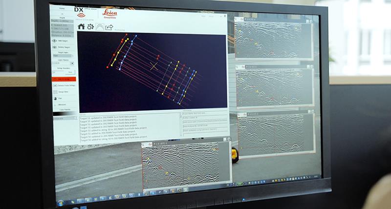
"name": "DX Office Vision",
"description": "DX Office Vision\nUtility post processing software\n\n\nDX Office Vision is Leica Geosystems’ Utility Post Processing Software that allows DS2000 users to map digitally the detected underground utilities in a simple way by converting GPR data into CAD drawings.\n\nKey benefits:\nCreate CAD drawings of the detected utilities in an uncomplicated way in minimum time and with less training.\nView collected data of the detected utilities in a simple way - compare data files side by side or from top to bottom to locate consistent features.\nObtain CAD drawings in 3D with object attributes in different layers – filter, select, identify and make annotations of consistent targets and anomalies.\nReduce processing time with no intermediate converting, third party software or patch required.\nVisualise radar data from your DS2000 with an intuitive interface.\nMerge your DX Office Vision Data with other Leica detection products like DS2000, Digicat and Ultra.\n \n\nTake over data processing into CAD drawings with confidence and simplicity\nFor utility surveyors looking to map digitally the detected underground utilities, DX Office Vision is the post processing software with the fastest conversion speed and most intuitive interface to convert GPR data into CAD drawings for every user. DX Office Vision was developed by utility mapping contractors who are every day on the field, and understand the need of delivering 3D CAD drawings in an efficient way.\n\nDX Office Vision features:\nAutomatic data import\nAutomatic pre-set filtering\nReal-world depth calibration\n3D CAD export\nTarget addition, Target connectivity, Depth filtering\nDX Office Vision X-Section:\nAdditional to DX Office Vision,\n\nVelocity Depth Calibration\n3D CAD view (fully navigable)\nTime Slice Function\n\n",
"price": 0.0,
"discountamount": 0.0,
"currencycode": "INR",
"priority": 1000000,
"isfreeshipmentavailable": false,
"shipmentduration": 7,
"_keywords": [
"3D CAD drawings",
"data processing",
"convert GPR data",
"intuitive interface",
"third party software",
"DX Office Vision Data",
"underground utilities",
"Office Vision features",
"compare data files side",
"Leica detection products",
"utility mapping contractors",
"Utility Post Processing Software"
],
"isarchived": false,
"isavailable": true,
"applicationid": null,
"productindex": 96,
"imageuri": "https://productimages.withfloats.com/actual/5b459f01d4575c0f14705198.jpg",
"tileimageuri": "https://productimages.withfloats.com/tile/5b459f01d4575c0f14705198.jpg",
"images": null,
"totalqueries": 0,
"gpid": null,
"groupproductid": null,
"createdon": "2018-07-11T06:08:57.374Z",
"updatedon": "2018-08-08T18:46:54.222Z",
"buyonlinelink": null,
"producturl": "http://WWW.SURVEYEQUIPMENT.IN//dx-office-vision/96",
"availableunits": -1.0,
"iscodavailable": true,
"isprepaidonlineavailable": false,
"maxcodorders": 0,
"maxprepaidonlineorders": 0,
"uniquepaymenturl": null,
"brandname": null,
"category": "Utility post processing software",
"tags": [
"Utility post processing software",
"Detection and underground mapping solution",
"GPR"
],
"variants": false,
"keyspecification": null,
"otherspecifications": null,
"pickupaddressreferenceid": "5d08ebb3edf0e25c3b8da5d0",
"paymenttype": "AssuredPurchase",
"producttype": "products",
"hsncode": null,
"gstslab": 0.0,
"isnotforsale": false
},
{
"_id": "5b6b3a9dd682be0552aefc54",
"fptag": "SBENTERPRISESTRADINGPUNE",
"merchantname": null,
"customwidgets": null,
"externalsourceid": null,
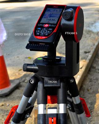
"name": "Leica Zeno 20 + DISTO S910: gamtec",
"description": "Leica Zeno 20 + DISTO S910: gamtec\nClosing GNSS gaps with point-to-point technology\n\nCombining the new Leica DISTO™ S910 with the Leica Zeno 20 changes how users collect asset information in GNSS-denied areas. With this signature gamtec technology, highly accurate distance and angular measurements from the DISTO™ S910 can be transferred on the fly to the Zeno 20, where data is imported in real time in your GIS – challenging GNSS areas are now problems of the past.\n\nA winning combination\nThe DISTO™ S910 can precisely measure directions and angles, and with the accurate positions delivered from the Zeno 20, you have a revolutionary instrument to capture inaccessible assets securely. Zeno Mobile running on the Zeno 20 allows you to effortlessly establish the connection and import the DISTO™ S910 measurements into your project - no post-editing is necessary.\n\nIn a simple and affordable way, remove the limitations of GNSS while increasing safety.\n\nOffset measuring \nSimply target the offset point and transfer necessary information via one click to the Zeno 20 where the offset point is generated in the user defined coordinate system.\n\nDifferent to compass-based solutions, the gamtec benefits from direction readings achieving much higher accuracies, which are further improved through stable tripod setup.\n\nSafely and accurately do offset measurements from one setup location while increasing productivity.\n\nRemoves the limitation of GNSS and close gaps in GNSS-denied areas in a simple and affordable way\nMaintain very high accuracy through mechanical angular reading, stable setup and highly accurate setup positioning\nIncrease safety - no need to cross a street to measure a point on the other side and no need to stand on a busy street to measure the gully",
"price": 0.0,
"discountamount": 0.0,
"currencycode": "INR",
"priority": 1000000,
"isfreeshipmentavailable": false,
"shipmentduration": 7,
"_keywords": [
"DISTO S910",
"S910 measurements",
"accurate distance",
"one setup location",
"measure directions",
"accurate positions",
"direction readings",
"offset measurements",
"angular measurements",
"Leica Zeno 20 changes",
"revolutionary instrument",
"mechanical angular reading",
"signature gamtec technology",
"capture inaccessible assets",
"transfer necessary information"
],
"isarchived": false,
"isavailable": true,
"applicationid": null,
"productindex": 85,
"imageuri": "https://productimages.withfloats.com/actual/5b3f3487d3d93d03a4b8fb73.jpg",
"tileimageuri": "https://productimages.withfloats.com/tile/5b3f3487d3d93d03a4b8fb73.jpg",
"images": null,
"totalqueries": 0,
"gpid": null,
"groupproductid": null,
"createdon": "2018-07-06T09:21:17.639Z",
"updatedon": "2018-08-08T18:46:53.791Z",
"buyonlinelink": null,
"producturl": "http://WWW.SURVEYEQUIPMENT.IN//leica-zeno-20-disto-s910-gamtec/85",
"availableunits": -1.0,
"iscodavailable": true,
"isprepaidonlineavailable": false,
"maxcodorders": 0,
"maxprepaidonlineorders": 0,
"uniquepaymenturl": null,
"brandname": null,
"category": "DGPS",
"tags": [
"DGPS",
"GNSS",
"GIS",
"laserdistancemeter"
],
"variants": false,
"keyspecification": null,
"otherspecifications": null,
"pickupaddressreferenceid": "5d08ebb3edf0e25c3b8da5d0",
"paymenttype": "AssuredPurchase",
"producttype": "products",
"hsncode": null,
"gstslab": 0.0,
"isnotforsale": false
}
],
"hasmoreitems": false,
"isapirequest": false,
"totalresults": 27,
"query": null,
"floatingpoint": null
}