Currently it only shows your basic business info. Start adding relevant business details such as description, images and products or services to gain your customers attention by using Boost 360
android app
/
iOS App/ web portal.
{
"products": [
{
"_id": "5b6b3a9bd682be0552aef931",
"fptag": "SBENTERPRISESTRADINGPUNE",
"merchantname": null,
"customwidgets": null,
"externalsourceid": null,
"name": "IBIS-FS Plus",
"description": "IBIS-FS Plus\nRemote static and dynamic monitoring with accelerometer to mitigate large external vibrations.\n\nAn advanced microwave interferometry based system for remote static and dynamic monitoring, IBIS-FS Plus inferometric radar is used on bridges and other structures including buildings, historical monuments and towers. An accelerometer version of IBIS-FS, this radar mitigates the effect of large external vibration sources on results.\n\nIn static, the IBIS-FS Plus is ideal for:\n\nStructure load testing;\nStructure displacement and collapse hazards;\nCultural heritage preservation.\nIn dynamic, the IBIS-FS Plus is best used for:\n\nStructure resonance frequency measurements;\nStructural modal shape analysis.\nIn either state, the IBIS-FS Plus features:\n\nRemote sensing: Real-time remote sensing at up to 1 km with no need for equipment to be installed on the monitored structure.\nAccurate measurements: Measures displacements of as little as 0.01mm @ 0.5km range. No standard instrument can achieve such accuracy.\nGround vibration removal: Built-in accelerometer to cancel the self-induced vibrations transmitted to the radar from the ground.\nSampling: Structural vibration sampling up to 200 Hz.\nAlways operational: Operates day and night and in all weather conditions.\nBenefits of the IBIS-FS Plus include:\n\nAccurate measurements even when the system is installed in places with large ground vibrations;\nIncrease structural health monitoring efficiency through the use of a non-invasive vibration monitoring technique;\nAccurate and remote real-time monitoring of structural vibration and natural frequencies;\nReduces the time required for static or dynamic bridge structural testing to just a few minutes",
"price": 0.0,
"discountamount": 0.0,
"currencycode": "INR",
"priority": 1000000,
"isfreeshipmentavailable": false,
"shipmentduration": 7,
"_keywords": [
"radar mitigates",
"vibration removal",
"dynamic monitoring",
"standard instrument",
"natural frequencies",
"Structural vibration",
"historical monuments",
"accelerometer version",
"Plus inferometric radar",
"large ground vibrations",
"vibration monitoring technique",
"large external vibration sources",
"resonance frequency measurements",
"dynamic bridge structural testing",
"structural health monitoring efficiency"
],
"isarchived": false,
"isavailable": true,
"applicationid": null,
"productindex": 41,
"imageuri": "https://productimages.withfloats.com/actual/5aefe578449b020bf493df68.jpg",
"tileimageuri": "https://productimages.withfloats.com/tile/5aefe578449b020bf493df68.jpg",
"images": null,
"totalqueries": 0,
"gpid": null,
"groupproductid": null,
"createdon": "2018-05-07T05:34:49.166Z",
"updatedon": "2018-08-08T18:46:51.305Z",
"buyonlinelink": null,
"producturl": "http://WWW.SURVEYEQUIPMENT.IN/products/ibis-fs-plus/41",
"availableunits": -1.0,
"iscodavailable": true,
"isprepaidonlineavailable": false,
"maxcodorders": 0,
"maxprepaidonlineorders": 0,
"uniquepaymenturl": null,
"brandname": null,
"category": null,
"tags": null,
"variants": false,
"keyspecification": null,
"otherspecifications": null,
"pickupaddressreferenceid": "5d08ebb3edf0e25c3b8da5d0",
"paymenttype": "AssuredPurchase",
"producttype": "products",
"hsncode": null,
"gstslab": 0.0,
"isnotforsale": false
},
{
"_id": "5b6b3a9bd682be0552aef908",
"fptag": "SBENTERPRISESTRADINGPUNE",
"merchantname": null,
"customwidgets": null,
"externalsourceid": null,
"name": "IBIS-FS",
"description": "IBIS-FS\nRemote monitoring for structural movements\n\nA microwave interferometry based system for remote static and dynamic monitoring, IBIS-FS interferometric radar is used on bridges and other structures including buildings, historical monuments and towers.\n\nIn static, the IBIS-FS is ideal for:\n\nStructure load testing;\nStructure displacement and collapse hazards;\nCultural heritage preservation.\nIn dynamic, the IBIS-FS is best used for:\n\nStructure resonance frequency measurements;\nStructural modal shape analysis.\nIn either state, the IBIS-FS features:\n\nRemote sensing: Real-time remote sensing at up to 1 km with no need for equipment to be installed on the monitored structure.\nAccurate measurements: Measures displacements of as little as 0.01mm @ 0.5km range. No standard instrument can achieve such accuracy.\nGround vibration removal: Built-in accelerometer to cancel the self-induced vibrations transmitted to the radar from the ground (IBIS-FS Plus).\nSampling: Structural vibration sampling up to 200 Hz.\nAlways operational: Operates day and night and in all weather conditions.\nBenefits of the IBIS-FS include:\n\nIncreased structural health monitoring efficiency through the use of a non-invasive vibration monitoring technique;\nAccurate and remote monitoring of a bridge or structure;\nReduces the time necessary for static or dynamic bridge structural testing to just a few minutes;\nReal-time data on structural vibration and natural frequencies;",
"price": 0.0,
"discountamount": 0.0,
"currencycode": "INR",
"priority": 1000000,
"isfreeshipmentavailable": false,
"shipmentduration": 7,
"_keywords": [
"remote static",
"time necessary",
"collapse hazards",
"remote monitoring",
"vibration removal",
"dynamic monitoring",
"standard instrument",
"natural frequencies",
"structural vibration",
"historical monuments",
"interferometric radar",
"vibration monitoring technique",
"resonance frequency measurements",
"dynamic bridge structural testing",
"structural health monitoring efficiency"
],
"isarchived": false,
"isavailable": true,
"applicationid": null,
"productindex": 39,
"imageuri": "https://productimages.withfloats.com/actual/5aefe528449b020bf493defb.jpg",
"tileimageuri": "https://productimages.withfloats.com/tile/5aefe528449b020bf493defb.jpg",
"images": null,
"totalqueries": 0,
"gpid": null,
"groupproductid": null,
"createdon": "2018-05-07T05:33:29.028Z",
"updatedon": "2018-08-08T18:46:51.203Z",
"buyonlinelink": null,
"producturl": "http://WWW.SURVEYEQUIPMENT.IN//ibis-fs/39",
"availableunits": -1.0,
"iscodavailable": true,
"isprepaidonlineavailable": false,
"maxcodorders": 0,
"maxprepaidonlineorders": 0,
"uniquepaymenturl": null,
"brandname": null,
"category": null,
"tags": null,
"variants": false,
"keyspecification": null,
"otherspecifications": null,
"pickupaddressreferenceid": "5d08ebb3edf0e25c3b8da5d0",
"paymenttype": "AssuredPurchase",
"producttype": "products",
"hsncode": null,
"gstslab": 0.0,
"isnotforsale": false
},
{
"_id": "5b6b3a9ed682be0552aefdfe",
"fptag": "SBENTERPRISESTRADINGPUNE",
"merchantname": null,
"customwidgets": null,
"externalsourceid": null,
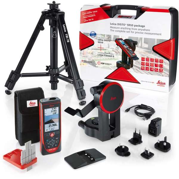
"name": "Leica Disto S910 - Pro Kit",
"description": "Leica Disto S910 - Pro Kit\nSpecial package promotion Leica DISTO™ S910 with tripod, adapter, target plate and carry case.\nMeasure quickly and accurate distances between two points from a single location with the Leica DISTO™ S910 laser distance meter. Generate effortlessly as-built documentation, determine rooftop dimensions and integrate information into CAD or BIM software for even 3D conceptions. This improved workflows saves valued time and money. All of this at distances of up to 300 meters.\n\nPro Kit includes\nLeica DISTO™ S910 laser distance meter\nSmart Base Extension\nHolster\nHand loop\nUSB charger incl. 4 plugs\nLeica FTA360-S tripod adapter\nLeica TRI 70 tripod\nLeica GZM3 target plate\nCarrying case\nFeatures include:\nSmart Base for P2P Technology\nPointfinder with 4x zoom for effortless targeting\nX-Range Power Technology for maximum measurement functioning\n360° tilt sensor\nDXF data capture\nData transfer in real-time with WLAN\nBluetooth® Smart\nFree Leica DISTO™ sketch App\nMeasure with P2P Technology\nThe incorporated Smart Base allows distances to be measured between any two points, inclinations and angles at the same time from a single location. You will never have to reach for remote areas again, allowing even the most complicated measurement job to be carried out accurately, quickly, and safely.\n\nAttain measurement data in CAD format\nThe Leica DISTO™ S910 laser measurer can save measured points to a DXF file as a wall layout, floor plan or 3D point coordinates which can be transferred to a PC via USB. Save money, reduce workflow and prevent mistakes. Everything is completely digital.\n\nTransfer point data in real-time\nEasily move measurement data promptly on site over the Wireless LAN interface to a transportable computer for additional processing in your favoured software. Produce documentation or assess lay-outs in real-time and communicate measurement points as you need with or without pictures.\n\nX-Range Power Technology\nThe state-of-the-art X-Range Power Technology included with the Leica DISTO™ S910 represents the future of measuring technology. It successfully measures distances of up to 300 meters and guarantees the optimum measuring functioning even to badly reflecting objects.\n\n \n\n£1,510.80\tinc VAT\n£1,259.00\texcl VAT\nQty: \n1\n Add to Basket\nIncludes FREE Next Day Delivery\nOrder by phone: 01480 404888\nCall our experienced sales team to order or discuss any products.\nCredit Card Logos\n\nSend to a Colleague\n\nDelivery and Returns\n\nLeica\n",
"price": 0.0,
"discountamount": 0.0,
"currencycode": "INR",
"priority": 1000000,
"isfreeshipmentavailable": false,
"shipmentduration": 7,
"_keywords": [
"Leica Disto S910",
"measurement data",
"Power Technology",
"accurate distances",
"S910 laser measurer",
"maximum measurement",
"3D point coordinates",
"Produce documentation",
"additional processing",
"transportable computer",
"Wireless LAN interface",
"package promotion Leica",
"S910 laser distance meter",
"determine rooftop dimensions",
"communicate measurement points"
],
"isarchived": false,
"isavailable": true,
"applicationid": null,
"productindex": 101,
"imageuri": "https://productimages.withfloats.com/actual/5b52e68d2b1777063123668e.jpg",
"tileimageuri": "https://productimages.withfloats.com/tile/5b52e68d2b1777063123668e.jpg",
"images": null,
"totalqueries": 0,
"gpid": null,
"groupproductid": null,
"createdon": "2018-07-21T07:53:48.529Z",
"updatedon": "2018-08-08T18:46:54.394Z",
"buyonlinelink": null,
"producturl": "http://WWW.SURVEYEQUIPMENT.IN//leica-disto-s910-pro-kit/101",
"availableunits": -1.0,
"iscodavailable": true,
"isprepaidonlineavailable": false,
"maxcodorders": 0,
"maxprepaidonlineorders": 0,
"uniquepaymenturl": null,
"brandname": null,
"category": "laserdistancemeter",
"tags": [
"laserdistancemeter",
"leicadisto",
"leicas910"
],
"variants": false,
"keyspecification": null,
"otherspecifications": null,
"pickupaddressreferenceid": "5d08ebb3edf0e25c3b8da5d0",
"paymenttype": "AssuredPurchase",
"producttype": "products",
"hsncode": null,
"gstslab": 0.0,
"isnotforsale": false
},
{
"_id": "5b6b3a9ed682be0552aefde4",
"fptag": "SBENTERPRISESTRADINGPUNE",
"merchantname": null,
"customwidgets": null,
"externalsourceid": null,
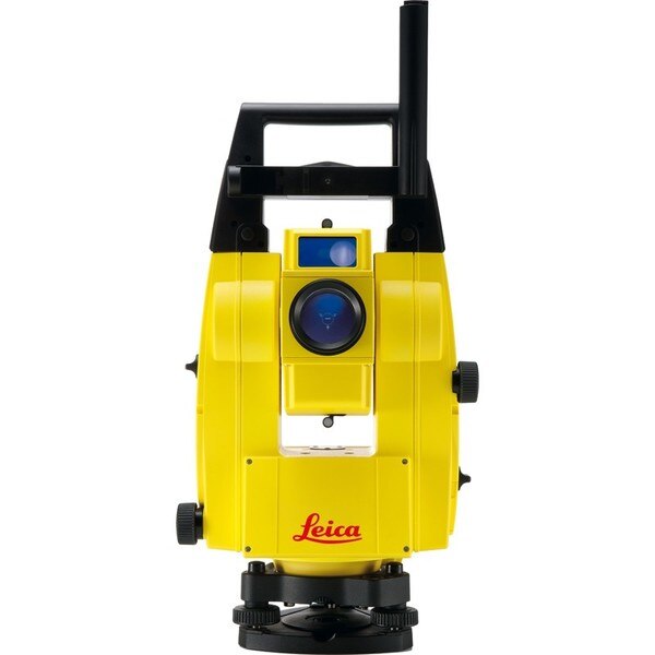
"name": "Leica iCON Robot 50",
"description": "Leica iCON Robot 50\nThe Leica iCON Robot 50 total station is operable using the field controller (iCON CC50) at the point of positioning using the prism pole, therefore there is no need for an operator at the instrument itself. This technology is extremely efficient and a highly accurate way of working.\n\nThe iCON robot 50 achieves the most precise reflector less measurements in its class. It features a simple one-button keyboard and patented PowerSearch option in order to find the prism quickly. Take advantage of applications through the custom-built software – iCONstruct. It also communicates using Bluetooth (up to 350m), WLAN (150m) and RS232 for different requirements, simply change the instrument handle to upgrade.\n\nWith very tight tolerances the Leica iCON Robot 50 is able to precisely control Graders, Dozers and Pavers automatically as well as set out or survey conventionally with one person. With the use of the most precise and accurate laser pointers the Leica Robot 50 is also able to layout points on ceilings or walls.\n\nFeatures\nExtremely precise reflectorless measurements\nSimple keyboard for easy use\nExcellent tracking\nRobust data communication\nGuide light\nand-over control from the rover\nWide range of apps with bespoke iCONstruct software\nIntegrates with all Leica iCON sensors\n\nLeica iCON robot 50 is designed specifically for ease of use within the construction industry, simply level the instrument and go.\n\nSave time and increase your productivity by doing layout work and as-built checks yourself. With iCON robot 50 you don’t need an operator at the instrument. The robotic total station can be operated from the field controller at the prism pole, at the point you need positioning.\n\nThe iCON robot 50 also delivers with:\n\nMost accurate reflectorless measurements in its class\nOne-button keyboard for simple operation\nFaster prism search by PowerSearch (patented technology)\nSuperior tracking performance ensures minimum machine downtime in machine control operation\nFlexible data communication: WLAN (150m range) or Long-range Bluetooth® (350m). Simply upgrade your communication by swapping the instrument handle\nEasy hand-over control from rover to machine control and vice versa\n \nOne-person robotic \nWith industry leading tracking performance and the patented PowerSearch technology, iCON robot 50 allows you to finish jobs faster maintaining highest accuracy.\n\nInterior overhead with laser pointer \nUsing one of the world’s most accurate laser pointers, remotely lay-out points on walls for drill patterns or on ceilings for air conditioning or other such projects.\n\nMachine control \nWork to the tightest tolerances under any site conditions. Carry out fine grading and paving with highest precision, speeding up your work with construction machinery.\n\nLimitless applications \nWith the iCONstruct software, you can use iCON robot 50 for a wide range of measuring and positioning tasks on site, such as:\n\nLayout\nStake-out\nGrade checking\nVolumes\nAs-built checks\nMachine control\n\n",
"price": 0.0,
"discountamount": 0.0,
"currencycode": "INR",
"priority": 1000000,
"isfreeshipmentavailable": false,
"shipmentduration": 7,
"_keywords": [
"Leica Robot 50",
"use iCON robot 50",
"iCONstruct software",
"iCON robot 50 allows",
"precise reflectorless",
"robotic total station",
"construction industry",
"iCON robot 50 achieves",
"PowerSearch technology",
"accurate laser pointers",
"Leica iCON Robot 50 total station",
"accurate reflectorless measurements",
"performance ensures minimum machine downtime"
],
"isarchived": false,
"isavailable": true,
"applicationid": null,
"productindex": 99,
"imageuri": "https://productimages.withfloats.com/actual/5b486c5af599f80511fd9ca6.jpg",
"tileimageuri": "https://productimages.withfloats.com/tile/5b486c5af599f80511fd9ca6.jpg",
"images": null,
"totalqueries": 0,
"gpid": null,
"groupproductid": null,
"createdon": "2018-07-13T09:09:46.162Z",
"updatedon": "2018-08-08T18:46:54.36Z",
"buyonlinelink": null,
"producturl": "http://WWW.SURVEYEQUIPMENT.IN//leica-icon-robot-50/99",
"availableunits": -1.0,
"iscodavailable": true,
"isprepaidonlineavailable": false,
"maxcodorders": 0,
"maxprepaidonlineorders": 0,
"uniquepaymenturl": null,
"brandname": null,
"category": "leicatotalstations",
"tags": [
"leicatotalstations",
"leicatotalstationsindia",
"robotictotalstations",
"leicatotalstationpune",
"leicaicon"
],
"variants": false,
"keyspecification": null,
"otherspecifications": null,
"pickupaddressreferenceid": "5d08ebb3edf0e25c3b8da5d0",
"paymenttype": "AssuredPurchase",
"producttype": "products",
"hsncode": null,
"gstslab": 0.0,
"isnotforsale": false
},
{
"_id": "5b6b3a9ed682be0552aefdd6",
"fptag": "SBENTERPRISESTRADINGPUNE",
"merchantname": null,
"customwidgets": null,
"externalsourceid": null,
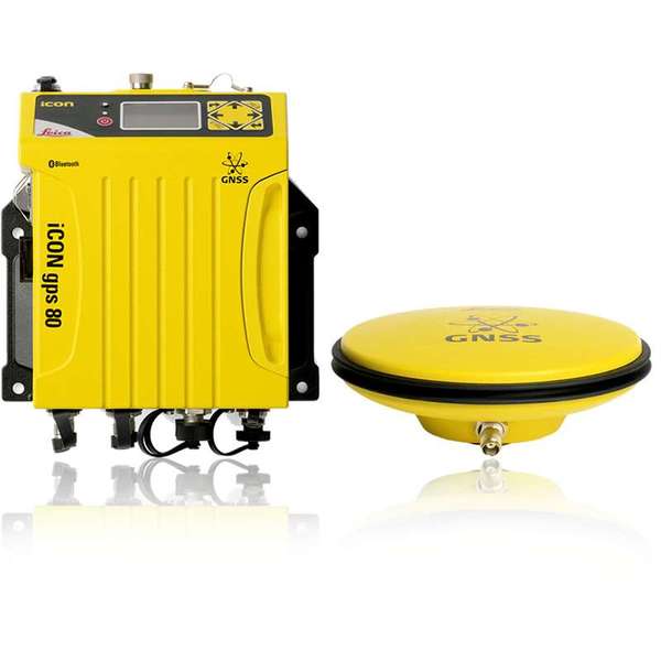
"name": "Leica iCON gps 80",
"description": "Leica iCON gps 80\nThe Leica iCON gps 80 GNSS machine receiver takes machine control to the next level.\nThe iCG80 GNSS receiver in combination with CGA 60 GNSS antenna increases the performance of your iCON machine control solution, allowing you to work more productively than ever before.\n\nIncrease dozer, excavator, drilling, excavator, wheel loader, grader and paver machine uptime. Enjoy the benefits from reliable, fast 3D positioning and productive operation via a high performance machine control system.\n\nKey benefits at a glance\nSensor integration with the machine system increases automatic handling, ease of use and work speed\nIncreased productivity and performance with all system elements fitting together\nCAN bus protocol specifically designed and created for GNSS machine control, providing reliable communication and increased uptime\nBuilt in modem and removable radios for flexible communication\nxRTK provides machine guidance and increases productivity in demanding environments\nLeica iCON telematics allows remote access to the machine computer fast data transfer and support\n\nUltimate performance for machine applications\nThe iCON GPS 80 GNSS machine receiver raises the performance of the machine control system to ensures maximum uptime and enabling applications to be done more quickly without compromising on quality.\n\n",
"price": 0.0,
"discountamount": 0.0,
"currencycode": "INR",
"priority": 1000000,
"isfreeshipmentavailable": false,
"shipmentduration": 7,
"_keywords": [
"machine guidance",
"machine computer",
"iCG80 GNSS receiver",
"GNSS machine control",
"paver machine uptime",
"machine control system",
"increases productivity",
"reliable communication",
"iCON machine control solution",
"CGA 60 GNSS antenna increases",
"high performance machine control",
"machine system increases automatic",
"Leica iCON gps 80 GNSS machine receiver"
],
"isarchived": false,
"isavailable": true,
"applicationid": null,
"productindex": 98,
"imageuri": "https://productimages.withfloats.com/actual/5b486344f599f80511fd98b1.jpg",
"tileimageuri": "https://productimages.withfloats.com/tile/5b486344f599f80511fd98b1.jpg",
"images": null,
"totalqueries": 0,
"gpid": null,
"groupproductid": null,
"createdon": "2018-07-13T08:31:00.378Z",
"updatedon": "2018-08-08T18:46:54.336Z",
"buyonlinelink": null,
"producturl": "http://WWW.SURVEYEQUIPMENT.IN/products/leica-icon-gps-80/98",
"availableunits": -1.0,
"iscodavailable": true,
"isprepaidonlineavailable": false,
"maxcodorders": 0,
"maxprepaidonlineorders": 0,
"uniquepaymenturl": null,
"brandname": null,
"category": "Topographical Survey",
"tags": [
"Topographical Survey",
"Transmission Line Survey",
"Survey Equipments",
"Geographical Survey",
"Road Survey"
],
"variants": false,
"keyspecification": null,
"otherspecifications": null,
"pickupaddressreferenceid": "5d08ebb3edf0e25c3b8da5d0",
"paymenttype": "AssuredPurchase",
"producttype": "products",
"hsncode": null,
"gstslab": 0.0,
"isnotforsale": false
},
{
"_id": "5b6b3a9dd682be0552aefc94",
"fptag": "SBENTERPRISESTRADINGPUNE",
"merchantname": null,
"customwidgets": null,
"externalsourceid": null,
"name": "Leica LOGiCAT VU Management & Monitoring System",
"description": "Leica LOGiCAT VU Management & Monitoring System\nAnalyse data to reduce utility strikes\n\nBy deploying Leica Digicat cable locators, utility strike rates have reduced dramatically. Now, with the introduction of Leica LOGiCAT VU software, cable locators can be managed and monitored centrally.\nData analysis helps fleet managers to improve cable locator usage and effectiveness during the excavation, increases attention to site safety initiative and enhances product familiarisation training and operator behaviour.\n\nWhat is Leica LOGiCAT VU?\nLeica LOGiCAT VU is a management and monitoring system for analysing data from cable locators.\nCable locators are used to identifying the location of buried utilities; the data enables instruments to record GPS coordinates alongside logged instrument data.\nLeica LOGiCAT VU helps plant, fleet and site managers to evaluate and analyse the data from one or more cable locators.\nThe system gives fleet managers a “view” of how the survey was conducted and if it has been undertaken to best practice. The locator positions can be mapped and presented through Google maps, highlighting the path of the survey.\n\nKey benefits\n\nGreater insight if best practice has been followed\nUsing just the cable locator on its own you could miss 45 up to 50% of dormant utilities which hold the potential of fatal injury. The Fleet Manager can evaluate the Leica LOGiCAT VU data and see how and if the Operator has thoroughly undertaken a site investigate, in all modes and with correct accessories, ensuring adherence to best practice.\n\nData visualisation on satellite images to support interpretation\nGPS enables cable locator to record their coordinates alongside usage data. Leica LOGiCAT VU displays field data overlaid on digital map and images, showing where the operator has undertaken the survey to support post-survey evaluation.Clarity for post utility strike evaluation. \n\nClarity for post utility strike evaluation\nIn the event of a utility strike, the incident report can be produced simply and provide a comprehensive and clear view of instruments usage leading up to the incident. Within the report, colours indicate the survey quality, Red/Poor and Green/Good.\n\nData export to GIS and BIM System\nThe instruments data can be exported to a third party GIS and BIM software enhancing knowledge about subsurface utilities for future excavation activities. ",
"price": 0.0,
"discountamount": 0.0,
"currencycode": "INR",
"priority": 1000000,
"isfreeshipmentavailable": false,
"shipmentduration": 7,
"_keywords": [
"instruments data",
"cable locator usage",
"alongside usage data",
"utility strike rates",
"subsurface utilities",
"Leica LOGiCAT VU data",
"enables cable locator",
"site safety initiative",
"data enables instruments",
"Leica LOGiCAT VU software",
"Leica LOGiCAT VU Management",
"post utility strike evaluation",
"deploying Leica Digicat cable locators",
"enhances product familiarisation training"
],
"isarchived": false,
"isavailable": true,
"applicationid": null,
"productindex": 88,
"imageuri": "https://productimages.withfloats.com/actual/5b45a062d3d93d01c4f0ed4e.jpg",
"tileimageuri": "https://productimages.withfloats.com/tile/5b45a062d3d93d01c4f0ed4e.jpg",
"images": null,
"totalqueries": 0,
"gpid": null,
"groupproductid": null,
"createdon": "2018-07-11T06:15:05.058Z",
"updatedon": "2018-08-08T18:46:53.924Z",
"buyonlinelink": null,
"producturl": "http://WWW.SURVEYEQUIPMENT.IN//leica-logicat-vu-management-monitoring-system/88",
"availableunits": -1.0,
"iscodavailable": true,
"isprepaidonlineavailable": false,
"maxcodorders": 0,
"maxprepaidonlineorders": 0,
"uniquepaymenturl": null,
"brandname": null,
"category": null,
"tags": null,
"variants": false,
"keyspecification": null,
"otherspecifications": null,
"pickupaddressreferenceid": "5d08ebb3edf0e25c3b8da5d0",
"paymenttype": "AssuredPurchase",
"producttype": "products",
"hsncode": null,
"gstslab": 0.0,
"isnotforsale": false
},
{
"_id": "5b6b3a9dd682be0552aefcbd",
"fptag": "SBENTERPRISESTRADINGPUNE",
"merchantname": null,
"customwidgets": null,
"externalsourceid": null,
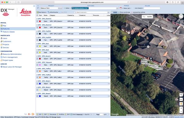
"name": "Leica DX Manager Mapping",
"description": "Leica DX Manager Mapping\nOne central dashboard for all the Leica Geosystems Detection solutions\n\nLeica DX Manager is the only enterprise grade utility mapping solution on the market. A unique cloud-powered solution that delivers unparalleled performance. Manage projects, tasks and spatial data from one central dashboard for all the Leica Geosystems Detection solutions.\n\nUpdate drawings, raw data, location pictures, data layers and mobile forms remotely and in a period of real time operate at an enterprise level rather than having to manually update individual users one at a time. With the Leica DX Manager, you have all dashboards, status updates and project management tools in one platform. Now, project managers can track field operations in real time and make critical decisions with a broader understanding of the current situation.\n\nKey benefits\n\nSimplified processes\nImprovement of data quality and accuracy\nConsistent data collection methods\nIntegration of DS2000, cable locators and asset mapping data\nWorkflows to maintain data integrity\nManage the whole workflow\n\nShare data to all devices and users within your organisation.\n\nAnalyse maps result\nVisualise on online maps\nFilter on users, within date ranges or any attributes\nExport to standard GIS and CAD formats\nShare data to your clients\nAn easy-to-use online portal allows management of all aspects of documenting utility location tasks. The user can switch between street view, satellite imagery and cartographic street maps. Field acquired survey data becomes instantly available and can be accessed by users anytime and anywhere.\n\nUtility detection integration\n\nLeica DX Manager integrates the entire Leica Geosystems Detection portfolio into a simple survey workflow, empowering the user to apply locator depth measurements to GNSS measurements. The result is a seamless fusion of both worlds – with all locator related data reviewable either in Leica DX Manager or any export format.\n\nLocate the utility\nMeasure the depth\nAll location data is sent directly to the Leica DX Field application on the GNSS device\nIt triggers the GNSS measurement on the mapping device\nAll data is integrated into the features metadata\nMaximum user experience and productivity\n\nLeica DX Field mobile app is designed for productivity and maximum user experience and built for enforcing data quality and accuracy. \n\nEasy mapping / surveying of assets\nSmart mobile forms\nImmediate visualisation on map\nMetadata collection\nAutomatic sync with Cloud\nFull offline capabilities\nMake sure your measured data always matches your quality expectations (up to centimetres with RTK) as Leica DX Manager notifications steadily monitor the system parameters. All quality parameters are stored as metadata. Next to the utility mapping aspect, it delivers work orders, time tracking and document management.",
"price": 0.0,
"discountamount": 0.0,
"currencycode": "INR",
"priority": 1000000,
"isfreeshipmentavailable": false,
"shipmentduration": 7,
"_keywords": [
"data quality",
"location data",
"data collection",
"data reviewable",
"survey data becomes",
"DX Field mobile app",
"Leica DX Manager Mapping",
"cartographic street maps",
"Leica DX Field application",
"update individual users one",
"Leica DX Manager notifications",
"apply locator depth measurements",
"enterprise grade utility mapping solution",
"entire Leica Geosystems Detection portfolio"
],
"isarchived": false,
"isavailable": true,
"applicationid": null,
"productindex": 89,
"imageuri": "https://productimages.withfloats.com/actual/5b459fa2f3579911b41e9cda.jpg",
"tileimageuri": "https://productimages.withfloats.com/tile/5b459fa2f3579911b41e9cda.jpg",
"images": null,
"totalqueries": 0,
"gpid": null,
"groupproductid": null,
"createdon": "2018-07-11T06:11:47.283Z",
"updatedon": "2018-08-08T18:46:53.959Z",
"buyonlinelink": null,
"producturl": "http://WWW.SURVEYEQUIPMENT.IN//leica-dx-manager-mapping/89",
"availableunits": -1.0,
"iscodavailable": true,
"isprepaidonlineavailable": false,
"maxcodorders": 0,
"maxprepaidonlineorders": 0,
"uniquepaymenturl": null,
"brandname": null,
"category": "GPR",
"tags": [
"GPR",
"Detection and underground mapping solution",
"Leica DX Manager Mapping"
],
"variants": false,
"keyspecification": null,
"otherspecifications": null,
"pickupaddressreferenceid": "5d08ebb3edf0e25c3b8da5d0",
"paymenttype": "AssuredPurchase",
"producttype": "products",
"hsncode": null,
"gstslab": 0.0,
"isnotforsale": false
},
{
"_id": "5b6b3a9cd682be0552aefaee",
"fptag": "SBENTERPRISESTRADINGPUNE",
"merchantname": null,
"customwidgets": null,
"externalsourceid": null,
"name": "Leica GPM3 Parallel Plate",
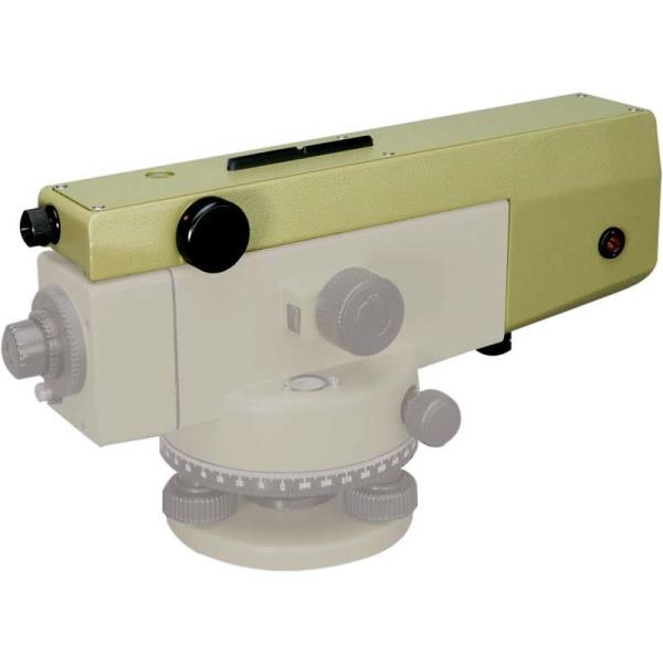
"description": "Leica GPM3 Parallel Plate\nThe Leica GPM3 parallel plate provides direct result readings to 0.1mm and approximated readings to 0.01mm. This makes both the NA2 and NAK2 into a precise and accurate level for monitoring and industrial measuring projects or deformation tasks.\n\n10”/2mm tubular level accuracy and with a double run with PPM 0.3mm per 1km",
"price": 0.0,
"discountamount": 0.0,
"currencycode": "INR",
"priority": 1000000,
"isfreeshipmentavailable": false,
"shipmentduration": 7,
"_keywords": [
"1km",
"PPM",
"NAK2",
"precise",
"projects",
"industrial",
"double run",
"deformation",
"accurate level",
"approximated readings",
"tubular level accuracy",
"direct result readings",
"Leica GPM3 parallel plate"
],
"isarchived": false,
"isavailable": true,
"applicationid": null,
"productindex": 66,
"imageuri": "https://productimages.withfloats.com/actual/5b1a511cab52d602c443a4b9.jpg",
"tileimageuri": "https://productimages.withfloats.com/tile/5b1a511cab52d602c443a4b9.jpg",
"images": null,
"totalqueries": 0,
"gpid": null,
"groupproductid": null,
"createdon": "2018-06-08T09:49:13.257Z",
"updatedon": "2018-08-08T18:46:52.36Z",
"buyonlinelink": null,
"producturl": "http://WWW.SURVEYEQUIPMENT.IN/products/leica-gpm3-parallel-plate/66",
"availableunits": -1.0,
"iscodavailable": true,
"isprepaidonlineavailable": false,
"maxcodorders": 0,
"maxprepaidonlineorders": 0,
"uniquepaymenturl": null,
"brandname": null,
"category": null,
"tags": null,
"variants": false,
"keyspecification": null,
"otherspecifications": null,
"pickupaddressreferenceid": "5d08ebb3edf0e25c3b8da5d0",
"paymenttype": "AssuredPurchase",
"producttype": "products",
"hsncode": null,
"gstslab": 0.0,
"isnotforsale": false
},
{
"_id": "5b6b3a9cd682be0552aefb16",
"fptag": "SBENTERPRISESTRADINGPUNE",
"merchantname": null,
"customwidgets": null,
"externalsourceid": null,
"name": "Leica NAK2 Automatic Level",
"description": "Leica NAK2 Automatic Level\nThe NAK2 automatic level is the flagship optical level product from Leica Geosystems. Designed by leading surveyors and developed by highly skilled engineers with a great deal of experience in knowing what an instrument must achieve in the field. Created for all types of surveying task. the NAK2 is economical and productive for routine levelling task on building sites, for geodetic control at all levels of accuracy, and in engineering projects.\n\nFeatures of the NAK2\n\nSuited for levelling of all orders and types of accuracy\nAccurate settlement and levelling determinations\nRoutine heighting for road, railway, pipeline, and tunnel construction\nControl measurements and setting-out work on site\nHigh accuracy area levelling\nK-version on flat terrain provides Tacheometric levelling by bringing together stadia and angular measurements with height readings\nBridge monitoring and deformation measurement\n \n\nThe NAK2 provides added angle measurement.\n\nThe model NAK2 has an internal glass circle which is read via a scale microscope and which can be set to any value by turning the rim around the base of the instrument. Tacheometric levelling is also available with the K-version on fl at terrain by combining stadia and angular measurements with height readings.\n\nGenerally, the NAK2 is able to set up on any Leica tripod. In most cases we recommend the heavy-duty Leica GST20 Wooden Tripod. For precise levelling the GST40 Wooden Tripod is suitable due to its extreme rigidity.\n\nThe durable and tough NAK2 can be used in varying weather conditions and very reliable when used in harsh working conditions such as the building site. The pendulum compensator is protected against shocks and the vibration damping mechanism is highly effective.\n\nSet up is quick and easy with the circular level only needing to be centred approximately and bring the compensator into its working range. The Pentaprism provides a positive bubble which is monitored down the eyepiece.\n\nThe high quality optics within the telescope provides bright, high contrast images which can be focussed on quickly.\n\nFor ease of use and the press of one button, the instantaneous check facility give complete confidence. Controls are well designed and arranged for added convenience and the endless horizontal drive enables rapid fine pointing.\n\nAccessories including the parallel-plate, laser eyepiece, increase the potential use of this impressive levelling instrument.",
"price": 0.0,
"discountamount": 0.0,
"currencycode": "INR",
"priority": 1000000,
"isfreeshipmentavailable": false,
"shipmentduration": 7,
"_keywords": [
"Leica Geosystems",
"GST40 Wooden Tripod",
"angular measurements",
"high contrast images",
"pendulum compensator",
"internal glass circle",
"routine levelling task",
"Tacheometric levelling",
"harsh working conditions",
"Leica GST20 Wooden Tripod",
"Leica NAK2 Automatic Level",
"instantaneous check facility",
"flagship optical level product",
"impressive levelling instrument",
"endless horizontal drive enables rapid fine"
],
"isarchived": false,
"isavailable": true,
"applicationid": null,
"productindex": 68,
"imageuri": "https://productimages.withfloats.com/actual/5b1a4e873b9b610fc8e459d0.jpg",
"tileimageuri": "https://productimages.withfloats.com/tile/5b1a4e873b9b610fc8e459d0.jpg",
"images": null,
"totalqueries": 0,
"gpid": null,
"groupproductid": null,
"createdon": "2018-06-08T09:38:15.903Z",
"updatedon": "2018-08-08T18:46:52.529Z",
"buyonlinelink": null,
"producturl": "http://WWW.SURVEYEQUIPMENT.IN/products/leica-nak2-automatic-level/68",
"availableunits": -1.0,
"iscodavailable": true,
"isprepaidonlineavailable": false,
"maxcodorders": 0,
"maxprepaidonlineorders": 0,
"uniquepaymenturl": null,
"brandname": null,
"category": null,
"tags": null,
"variants": false,
"keyspecification": null,
"otherspecifications": null,
"pickupaddressreferenceid": "5d08ebb3edf0e25c3b8da5d0",
"paymenttype": "AssuredPurchase",
"producttype": "products",
"hsncode": null,
"gstslab": 0.0,
"isnotforsale": false
}
],
"hasmoreitems": false,
"isapirequest": false,
"totalresults": 27,
"query": null,
"floatingpoint": null
}