Preview

This is your website preview.

Currently it only shows your basic business info. Start adding relevant business details such as description, images and products or services to gain your customers attention by using Boost 360 android app / iOS App / web portal.

SBENTERPRISESTRADINGPUNE 5abfbf1e7c88bb04a4d0fcc7 Products https://www.surveyequipment.in
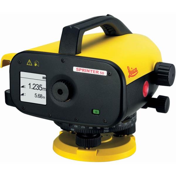
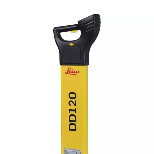
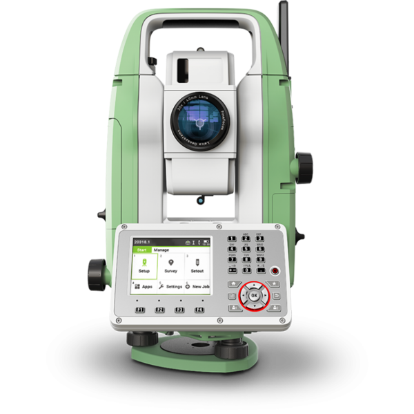
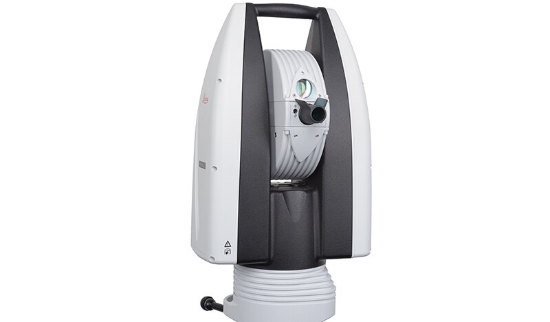
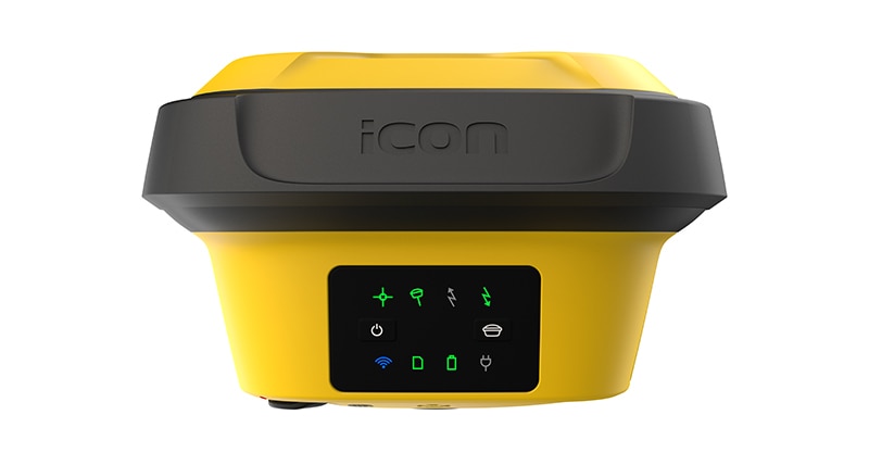
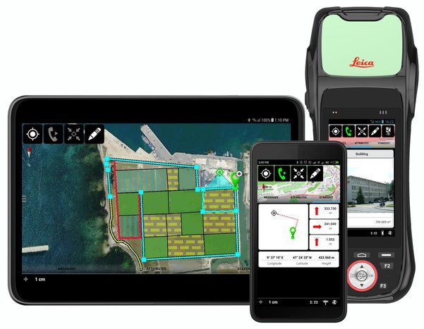
{ "products": [ { "_id": "5b6b3a9dd682be0552aefc94", "fptag": "SBENTERPRISESTRADINGPUNE", "merchantname": null, "customwidgets": null, "externalsourceid": null, "name": "Leica LOGiCAT VU Management & Monitoring System", "description": "Leica LOGiCAT VU Management & Monitoring System\nAnalyse data to reduce utility strikes\n\nBy deploying Leica Digicat cable locators, utility strike rates have reduced dramatically. Now, with the introduction of Leica LOGiCAT VU software, cable locators can be managed and monitored centrally.\nData analysis helps fleet managers to improve cable locator usage and effectiveness during the excavation, increases attention to site safety initiative and enhances product familiarisation training and operator behaviour.\n\nWhat is Leica LOGiCAT VU?\nLeica LOGiCAT VU is a management and monitoring system for analysing data from cable locators.\nCable locators are used to identifying the location of buried utilities; the data enables instruments to record GPS coordinates alongside logged instrument data.\nLeica LOGiCAT VU helps plant, fleet and site managers to evaluate and analyse the data from one or more cable locators.\nThe system gives fleet managers a “view” of how the survey was conducted and if it has been undertaken to best practice. The locator positions can be mapped and presented through Google maps, highlighting the path of the survey.\n\nKey benefits\n\nGreater insight if best practice has been followed\nUsing just the cable locator on its own you could miss 45 up to 50% of dormant utilities which hold the potential of fatal injury. The Fleet Manager can evaluate the Leica LOGiCAT VU data and see how and if the Operator has thoroughly undertaken a site investigate, in all modes and with correct accessories, ensuring adherence to best practice.\n\nData visualisation on satellite images to support interpretation\nGPS enables cable locator to record their coordinates alongside usage data. Leica LOGiCAT VU displays field data overlaid on digital map and images, showing where the operator has undertaken the survey to support post-survey evaluation.Clarity for post utility strike evaluation. \n\nClarity for post utility strike evaluation\nIn the event of a utility strike, the incident report can be produced simply and provide a comprehensive and clear view of instruments usage leading up to the incident. Within the report, colours indicate the survey quality, Red/Poor and Green/Good.\n\nData export to GIS and BIM System\nThe instruments data can be exported to a third party GIS and BIM software enhancing knowledge about subsurface utilities for future excavation activities. ", "price": 0.0, "discountamount": 0.0, "currencycode": "INR", "priority": 1000000, "isfreeshipmentavailable": false, "shipmentduration": 7, "_keywords": [ "instruments data", "cable locator usage", "alongside usage data", "utility strike rates", "subsurface utilities", "Leica LOGiCAT VU data", "enables cable locator", "site safety initiative", "data enables instruments", "Leica LOGiCAT VU software", "Leica LOGiCAT VU Management", "post utility strike evaluation", "deploying Leica Digicat cable locators", "enhances product familiarisation training" ], "isarchived": false, "isavailable": true, "applicationid": null, "productindex": 88, "imageuri": "https://productimages.withfloats.com/actual/5b45a062d3d93d01c4f0ed4e.jpg", "tileimageuri": "https://productimages.withfloats.com/tile/5b45a062d3d93d01c4f0ed4e.jpg", "images": null, "totalqueries": 0, "gpid": null, "groupproductid": null, "createdon": "2018-07-11T06:15:05.058Z", "updatedon": "2018-08-08T18:46:53.924Z", "buyonlinelink": null, "producturl": "http://WWW.SURVEYEQUIPMENT.IN//leica-logicat-vu-management-monitoring-system/88", "availableunits": -1.0, "iscodavailable": true, "isprepaidonlineavailable": false, "maxcodorders": 0, "maxprepaidonlineorders": 0, "uniquepaymenturl": null, "brandname": null, "category": null, "tags": null, "variants": false, "keyspecification": null, "otherspecifications": null, "pickupaddressreferenceid": "5d08ebb3edf0e25c3b8da5d0", "paymenttype": "AssuredPurchase", "producttype": "products", "hsncode": null, "gstslab": 0.0, "isnotforsale": false }, { "_id": "5b6b3a9cd682be0552aefab1", "fptag": "SBENTERPRISESTRADINGPUNE", "merchantname": null, "customwidgets": null, "externalsourceid": null, "name": "Leica Sprinter 50 Digital Level", "description": "Leica Sprinter 50 Digital Level\nLeica Sprinter 50 essential primary construction work\nThe Leica Sprinter 50 digital level is the perfect instrument for standard daily levelling work. Simply target and focus then click one button to measure. Results are calculated quickly and with functions that reduce errors, including the tilt sensor which prevents measurements being taken if the operator is outside the compensator range. Read the results with confidence knowing that they are all error free!\n\nAccurate Optics\nMake use of the highly accurate optical elements and use as a standard level by focusing on the staff in the traditional manor.\n\nOne Click Action\nSimple and easy to use one press button, the Sprinter 50 doesn’t require any comprehensive training. Point and shoot, that’s it!\n\nRead\nWith the use of a bar coded staff there is no need for optical readings. The staff itself ascertains both the height and distance which is then shown on the very clear LCD display. This avoids confusion when reading the results.\n\nIncludes:\nLeica Sprinter 50 Digital Level\n4x AA Batteries\nCarry Case\nUser Manual\n", "price": 0.0, "discountamount": 0.0, "currencycode": "INR", "priority": 1000000, "isfreeshipmentavailable": false, "shipmentduration": 7, "_keywords": [ "tilt sensor", "standard level", "standard daily", "click one button", "optical readings", "avoids confusion", "compensator range", "clear LCD display", "perfect instrument", "use one press button", "prevents measurements", "comprehensive training", "accurate optical elements", "Leica Sprinter 50 digital level", "Sprinter 50 essential primary construction" ], "isarchived": false, "isavailable": true, "applicationid": null, "productindex": 63, "imageuri": "https://productimages.withfloats.com/actual/5affeb7e6061cb0720599ded.jpg", "tileimageuri": "https://productimages.withfloats.com/tile/5affeb7e6061cb0720599ded.jpg", "images": null, "totalqueries": 0, "gpid": null, "groupproductid": null, "createdon": "2018-05-19T09:16:44.829Z", "updatedon": "2018-08-08T18:46:52.218Z", "buyonlinelink": null, "producturl": "http://WWW.SURVEYEQUIPMENT.IN/products/leica-sprinter-50-digital-level/63", "availableunits": -1.0, "iscodavailable": true, "isprepaidonlineavailable": false, "maxcodorders": 0, "maxprepaidonlineorders": 0, "uniquepaymenturl": null, "brandname": null, "category": null, "tags": null, "variants": false, "keyspecification": null, "otherspecifications": null, "pickupaddressreferenceid": "5d08ebb3edf0e25c3b8da5d0", "paymenttype": "AssuredPurchase", "producttype": "products", "hsncode": null, "gstslab": 0.0, "isnotforsale": false }, { "_id": "6538b3519c14ab0f94083db9", "fptag": "SBENTERPRISESTRADINGPUNE", "merchantname": null, "customwidgets": null, "externalsourceid": null, "name": "Leica DD120 Cable Loctoer ", "description": "Easy to use, intuitive avoidance tool\nThe new Leica DD120 locator reduces the complexity normally associated with scanning for buried utilities. For construction professionals who need to know what is beneath their sites, the DD120 cable locator is a simple, intuitive locator designed to detect and avoid buried utilities. The DD120’s automated pinpointing process improves the detection of utilities, reduces utility damage and increases workforce safety.\nAutomatic pinpointing\nPower, Radio, Auto modes\nTransmitter, 33kHz, 8kHz\nDepth detection up to 3 meters (10 feet)\nGood-to-Go™ Health Check and Start up test\nIP54 rating - protection from dust and water\n1 year Warranty\n\nHandheld multi-frequency underground service locatorThe Leica DD100 Series cable locators feature advanced automatic controls making the DD100 Series easy-to-use, requiring minimal user experience. Avoiding underground cables and pipes is a major concern on construction sites. Therefore, detecting the position of buried cables and pipes before excavation work can help prevent operator injury, asset damage and any subsequent costs. Use the DD120 or DD130 cable locators in conjunction with a DA220 or DA230 signal transmitter or range of accessories to achieve improved accuracy and application scope.\nUnmatched ease of useWith Automatic Pinpointing there is no need for you to manually adjust the sensitivity of your Digicat cable locator ensuring you’re using the optimum sensitivity for the environment you are detecting the underground utilities in. Reducing the likelihood of human error and enabling easier and more efficient cable and pipe locating. Ultimately saving you time and money.\n\nUnderground Exploration with Leica DD120User-Centric Design: Effortless operation with an in-built self-test for accuracy assurance.Dynamic Alert System: Hazard Zone alert for shallow services within 30cm ensures enhanced safety.Versatile Modes: Detect in Auto, Power, Radio, and Transmitter modes for comprehensive utility detection.\n\n", "price": 0.0, "discountamount": 0.0, "currencycode": "INR", "priority": 1000000, "isfreeshipmentavailable": false, "shipmentduration": 7, "_keywords": null, "isarchived": false, "isavailable": true, "applicationid": null, "productindex": 232, "imageuri": "https://productimages.withfloats.com/actual/6538b35d9144637b5496fab1.jpg", "tileimageuri": "https://productimages.withfloats.com/tile/6538b35d9144637b5496fab1.jpg", "images": null, "totalqueries": 0, "gpid": null, "groupproductid": null, "createdon": "2023-10-25T06:18:57.85Z", "updatedon": "2023-10-25T06:18:57.85Z", "buyonlinelink": null, "producturl": "http://WWW.SURVEYEQUIPMENT.IN/products/leica-dd120-cable-loctoer-/232", "availableunits": -1.0, "iscodavailable": false, "isprepaidonlineavailable": false, "maxcodorders": 0, "maxprepaidonlineorders": 0, "uniquepaymenturl": null, "brandname": "Leica", "category": "Pipe and Cable locators", "tags": null, "variants": false, "keyspecification": null, "otherspecifications": null, "pickupaddressreferenceid": "", "paymenttype": "None", "producttype": "products", "hsncode": null, "gstslab": 0.0, "isnotforsale": false }, { "_id": "5daaf779f9dc390001952ef9", "fptag": "SBENTERPRISESTRADINGPUNE", "merchantname": null, "customwidgets": null, "externalsourceid": null, "name": "Leica FlexLine TS07 Manual Total Station", "description": "Leica FlexLine TS07 Manual Total Station\nThe Leica FlexLine TS07 high-quality, manual total station is based on a proven product concept that has been revolutionising the world of measurement and survey for nearly 200 years. The Leica TS07 is equipped with a comprehensive application-based software package - Leica FlexField software - that enables most survey and stakeout tasks to be carried out easily and efficiently. The new FlexLine TS07 works reliably and delivers accurate results even in the harshest environments.\n\nWork faster: measure more points per day due to faster measurement and stakeout procedures (endless drives, trigger key, drives on both sides, pinpoint EDM and more), supported by our comprehensive and user-friendly Leica FlexField software.\nUse it trouble-free: increase productivity and minimise downtime by relying on instruments that simply work and come with a global service and support network.\nChoose products that are built to last: FlexLine operates with the same high level of quality even after years of use under harsh conditions (like mud, dust, blowing rain, extreme heat and cold).\nControl your investment: reliability, speed and accuracy ensure a lower investment over the product lifetime and a higher resell value.\nSave time with AutoHeight: measure, read and set the instrument height automatically with this revolutionary feature in the FlexLine TS07 (optional). Errors are minimised and the setup process onsite is faster.", "price": 0.0, "discountamount": 0.0, "currencycode": "INR", "priority": 1000000, "isfreeshipmentavailable": false, "shipmentduration": 7, "_keywords": null, "isarchived": false, "isavailable": true, "applicationid": null, "productindex": 156, "imageuri": "https://productimages.withfloats.com/actual/5daaf77b836b6b0001c86cb4.png", "tileimageuri": "https://productimages.withfloats.com/tile/5daaf77b836b6b0001c86cb4.png", "images": null, "totalqueries": 0, "gpid": null, "groupproductid": null, "createdon": "2019-10-19T11:46:01.098Z", "updatedon": "2019-10-19T11:46:01.098Z", "buyonlinelink": null, "producturl": "http://WWW.SURVEYEQUIPMENT.IN/products/leica-flexline-ts07-manual-total-station/156", "availableunits": -1.0, "iscodavailable": false, "isprepaidonlineavailable": false, "maxcodorders": 0, "maxprepaidonlineorders": 0, "uniquepaymenturl": null, "brandname": "Leica Geosystems ", "category": "", "tags": null, "variants": false, "keyspecification": null, "otherspecifications": null, "pickupaddressreferenceid": "", "paymenttype": "None", "producttype": "products", "hsncode": null, "gstslab": 0.0, "isnotforsale": false }, { "_id": "5d4e66ac5c6ebf0001143d5b", "fptag": "SBENTERPRISESTRADINGPUNE", "merchantname": null, "customwidgets": null, "externalsourceid": null, "name": "Leica Absolute Tracker AT960", "description": "Leica Absolute Tracker AT960\nLaser Tracker Systems\nHigh-accuracy probing, scanning and reflector measurement for large-volume industrial applications\n\n\n\nHigh-performance 6DoF laser tracker technology in an ultra-portable and easy-to-use form factor.\n\n\n\nThe Leica Absolute Tracker AT960 is a robust, all-in-one laser tracker that fits in a single flight case. Offering high-speed dynamic measurement as standard, it is a complete solution for six degrees of freedom (6DoF) probing, scanning and automated inspection as well as reflector measurement.\n\n\nA new generation of portable CMM system based on proven technology, the AT960 brings together the 6DoF functionality introduced with the Leica Absolute Tracker AT901 and the portability and usability delivered by the compact Leica Absolute Tracker AT403. The result is a highly-sophisticated yet easy-to-use large-volume measurement solution weighing less than 14 kilograms.\n\nThe AT960 laser tracker can be transported easily, unpacked quickly and powered up in minutes to deliver high-performance measurement almost anywhere. Dynamic features and flexible functionality give users absolute speed, accuracy and portability.\n\nFeaturing wireless communication and a battery operation option, the integrated-technology design of the AT960 makes lengthy setup a thing of the past. The Leica Absolute Interferometer (AIFM) enables accurate high-speed measurement to a moving target while the innovative PowerLock function ensures an interrupted beam is instantly re-established without user intervention, reducing operator workload and training requirements. Intuitive touch-screen controls minimise the potential for user error, saving time, effort and money. Check and compensation architecture means basic adjustments can be made in the field, while robust design guarantees on-specification operations with minimal calibration and servicing\n\nWhen combined with the Real-Time Feature Pack and Leica T-Mac, the AT960 evolves into a laser tracker solution that meets the deterministic measurement data-delivery requirements of high-end automated installations. Built on the industry-proven EtherCAT protocol, it enables the delivery of 6DoF measurement data with accurate timestamps at an output rate of up to 1000 Hertz. Known as 7DoF measurement data, this enables real-time machine control within even highly-dynamic robotic setups.\n\nWith a measurement volume of up to 160 metres in diameter, the AT960 is compatible with Leica T-Probe, Leica T-Mac, Leica T-Scan 5 and Leica Absolute Scanner technology. This flexibility allows it to cater to a wide variety of inspection applications – from quality lab to in-line; from in the factory to in the field – ensuring users have the right tool for any measurement challenge.\n\n", "price": 0.0, "discountamount": 0.0, "currencycode": "INR", "priority": 1000000, "isfreeshipmentavailable": false, "shipmentduration": 7, "_keywords": null, "isarchived": false, "isavailable": true, "applicationid": null, "productindex": 150, "imageuri": "https://productimages.withfloats.com/actual/5d4e66adb409c900010d17d6.jpg", "tileimageuri": "https://productimages.withfloats.com/tile/5d4e66adb409c900010d17d6.jpg", "images": null, "totalqueries": 0, "gpid": null, "groupproductid": null, "createdon": "2019-08-10T06:39:40.851Z", "updatedon": "2019-08-10T06:39:40.851Z", "buyonlinelink": null, "producturl": "http://WWW.SURVEYEQUIPMENT.IN/products/leica-absolute-tracker-at960/150", "availableunits": -1.0, "iscodavailable": false, "isprepaidonlineavailable": false, "maxcodorders": 0, "maxprepaidonlineorders": 0, "uniquepaymenturl": null, "brandname": "Leica ", "category": "", "tags": [ "laser tracker" ], "variants": false, "keyspecification": null, "otherspecifications": null, "pickupaddressreferenceid": "", "paymenttype": "None", "producttype": "products", "hsncode": null, "gstslab": 0.0, "isnotforsale": false }, { "_id": "5c839daa0eac470001975d08", "fptag": "SBENTERPRISESTRADINGPUNE", "merchantname": null, "customwidgets": null, "externalsourceid": null, "name": "Leica iCON gps 70 Series", "description": "Leica iCON gps 70 Series\nPermanent tilt compensation and resistance to magnetic interferences – Leica iCON gps 70 T\n\n\nLeica iCON gps 70 Series – Ultimate performance for your construction site\nUltimate GNSS Rover and field solution for maximum efficiency. Speed up – anytime, anywhere. Leica Geosystems introduces the most efficient construction GNSS rovers, the Leica iCON gps 70 Series. Combining the latest GNSS technology and inertial measurement unit (IMU), the Leica iCON gps 70 T is equipped with permanent tilt compensation and as well resistant to any magnetic interferences. Being calibration-free, the iCON gps 70 T is ready when you are – anytime, anywhere. The iCON gps 70 T releases the limitations of working with the pole in vertical positions and increases the productivity compared to conventional methods. Furthermore, the efficiency on a construction site is enhanced by collecting as-built field data and staking out designs faster, while increasing accuracy and reducing errors. Without time-consuming procedures, users measure where it was not possible before with improved quality control. The seamless integration of the Leica iCON gps 70 Series into the Leica iCON field software leads to simple workflows which require less training and avoid costly downtime.\n\n\nDGPS Surveying Instruments\nDGPS Surveying Instruments - Positioning System Retailer from Mumbai\n\nDGPS Surveying Instruments - Positioning System Retailer from Pune\n\nDGPS Surveying Instruments - Positioning System Retailer from India\n\nDGPS Surveying Instruments - Positioning System Retailer from Maharashtra\n\nGPS Survey Equipment\n\nDifferential GPS India\n\nDifferential Global Positioning System (DGPS) from Mumbai\n\nDifferential Global Positioning System (DGPS) from Pune\n\nDifferential Global Positioning System (DGPS) from India\n\nDifferential Global Positioning System (DGPS) from Maharashtra\n\nGNSS/GPS Survey Equipment - Surveying Equipment from Mumbai\n\nGNSS/GPS Survey Equipment - Surveying Equipment from Pune\n\nGNSS/GPS Survey Equipment - Surveying Equipment from India\n\nGNSS/GPS Survey Equipment - Surveying Equipment from Maharashtra\n\nConstruction Surveying Equipment, Surveying Instruments in India‎\n\n \n\n", "price": 0.0, "discountamount": 0.0, "currencycode": "INR", "priority": 1000000, "isfreeshipmentavailable": false, "shipmentduration": 7, "_keywords": [ "Survey Equipment", "Leica iCON gps 70 T", "Surveying Equipment", "Surveying Instruments", "iCON gps 70 T releases", "Leica iCON gps 70 Series", "Global Positioning System", "Leica iCON field software", "inertial measurement unit", "Positioning System Retailer", "permanent tilt compensation", "efficient construction GNSS rovers" ], "isarchived": false, "isavailable": true, "applicationid": null, "productindex": 141, "imageuri": "https://productimages.withfloats.com/actual/5c839dabdc44740001742988.jpg", "tileimageuri": "https://productimages.withfloats.com/tile/5c839dabdc44740001742988.jpg", "images": null, "totalqueries": 0, "gpid": null, "groupproductid": null, "createdon": "2019-03-09T11:04:10.316Z", "updatedon": "2019-03-09T11:04:10.316Z", "buyonlinelink": null, "producturl": "http://WWW.SURVEYEQUIPMENT.IN/products/leica-icon-gps-70-series/141", "availableunits": -1.0, "iscodavailable": true, "isprepaidonlineavailable": false, "maxcodorders": 0, "maxprepaidonlineorders": 0, "uniquepaymenturl": null, "brandname": null, "category": "DGPS Surveying Instruments", "tags": [ "DGPS Surveying Instruments", "Differential GPS India", "DGPS Surveying Instruments - Positioning System Re", "GNSS/GPS Survey Equipment - Surveying Equipment fr" ], "variants": false, "keyspecification": null, "otherspecifications": null, "pickupaddressreferenceid": "5d08ebb3edf0e25c3b8da5d0", "paymenttype": "AssuredPurchase", "producttype": "products", "hsncode": null, "gstslab": 0.0, "isnotforsale": false }, { "_id": "5bcdaac7e3f0b00001d2a048", "fptag": "SBENTERPRISESTRADINGPUNE", "merchantname": null, "customwidgets": null, "externalsourceid": null, "name": "RIS One & RIS Plus", "description": "RIS One & RIS Plus\nCompact and lightweight ground penetrating radar\n\nRIS ONE and RIS PLUS are the most compact and lightweight antennas available on the market. Gain increased acquisition speed through a high stacking factor as well as improved penetration depth with these single or multi-channel radar control unit.\n\nThe system is supported by antennas operating in 25 MHz to 2.6 GHz frequency range. Custom solutions are available with the IDS GeoRadar control unit, able to power up multiple antennas connected in chain. The antennas feature:\n\nExcellent data quality\nHighest flexibility in multi-channel chain connection\nHigh stacking thereby improving penetration depth\nWireless link to keep track of the survey path and the location of buried objects;\nRIS ONE and RIS PLUS are the ideal solutions for:\n\nUnderground tunnel inspection and condition assessment;\nBedrock and lithological profiling;\nFracture characterisation;\nGround water profiling;\nFoundation and pile measurements;\nBorehole investigations.\nBenefits of the RIS ONE and RIS PLUS include:\n\nLargest antenna gamma in the ground penetrating radar market: A comprehensive set of antennas from 25 MHz to 3.0 GHz, including multi-frequency, borehole and horn antennas ensuring that the right equipment is available for the right application.\nMore than eight hours of autonomous use: IDS GeoRadar’s radar control unit has the lowest power consumption in the ground penetrating radar market.\nFlexible: The multi-channel DAD control unit can drive any IDS Georadar antenna and up to eight antennas in chain connection simultaneously enabling the use of custom configurations.\n\n\n", "price": 0.0, "discountamount": 0.0, "currencycode": "INR", "priority": 1000000, "isfreeshipmentavailable": false, "shipmentduration": 7, "_keywords": null, "isarchived": false, "isavailable": true, "applicationid": null, "productindex": 118, "imageuri": "https://productimages.withfloats.com/actual/5bcdaac884ac000001a78fc7.jpg", "tileimageuri": "https://productimages.withfloats.com/tile/5bcdaac884ac000001a78fc7.jpg", "images": null, "totalqueries": 0, "gpid": null, "groupproductid": null, "createdon": "2018-10-22T10:47:35.934Z", "updatedon": "2018-10-22T10:47:35.934Z", "buyonlinelink": null, "producturl": "http://WWW.SURVEYEQUIPMENT.IN/products/ris-one-ris-plus/118", "availableunits": -1.0, "iscodavailable": true, "isprepaidonlineavailable": false, "maxcodorders": 0, "maxprepaidonlineorders": 0, "uniquepaymenturl": null, "brandname": null, "category": null, "tags": null, "variants": false, "keyspecification": null, "otherspecifications": null, "pickupaddressreferenceid": "5d08ebb3edf0e25c3b8da5d0", "paymenttype": "AssuredPurchase", "producttype": "products", "hsncode": null, "gstslab": 0.0, "isnotforsale": false }, { "_id": "5b91054f2626a60521ac8372", "fptag": "SBENTERPRISESTRADINGPUNE", "merchantname": null, "customwidgets": null, "externalsourceid": null, "name": "Leica Zeno Mobile", "description": "Leica Zeno Mobile\nIntuitive data capture\n\nLeica Zeno Mobile is an Android™ app available on the Leica Zeno 20 and selected Android smartphones and tablets.\n\nƒ Supports Leica Zeno 20, selected\nsmartphones and tablets with Android\nv5.0 or higher\nƒ Connect to Leica Zeno GNSS devices to\nutilise high accuracy data collection\nƒ Simple and intuitive user interface\nand workflows with minimum training\nrequired\nƒ Different versions of Zeno Mobile\navailable depending on your needs \n\nInteraction with Zeno Mobile is simple and\nintuitive, providing advanced functionality\nwithout the need for extensive training.\nƒ Import and export data to\ncloud service\nƒ Multi-touch support for easy\nmap orientation\nƒ Use OpenStreetMap or your own\nbackground maps instantly via WMS\nƒ Supports wide range of GIS and CAD\ndata formats\n\nZeno Mobile saves you time in the field by\nenabling you to capture more data quicker.\nƒ Data collection projects can be setup\non the fly without the need for other\nsoftware\nƒ Capture inaccessible points using\nGAMtec (Zeno 20 only)\nƒ Capture multiple features at the same\ntime using the multi-collect function\nƒ Connect to cable detection devices\nƒ Stakeout tool for precision location\nƒ Easily import and export data with\nLeica Zeno Office", "price": 0.0, "discountamount": 0.0, "currencycode": "INR", "priority": 1000000, "isfreeshipmentavailable": false, "shipmentduration": 7, "_keywords": null, "isarchived": false, "isavailable": true, "applicationid": null, "productindex": 112, "imageuri": "https://productimages.withfloats.com/actual/5b91054f8b91ff054a4ed0cc.jpg", "tileimageuri": "https://productimages.withfloats.com/tile/5b91054f8b91ff054a4ed0cc.jpg", "images": null, "totalqueries": 0, "gpid": null, "groupproductid": null, "createdon": "2018-09-06T10:45:35.843Z", "updatedon": "2018-09-06T10:45:35.843Z", "buyonlinelink": null, "producturl": "http://WWW.SURVEYEQUIPMENT.IN/products/leica-zeno-mobile/112", "availableunits": -1.0, "iscodavailable": true, "isprepaidonlineavailable": false, "maxcodorders": 0, "maxprepaidonlineorders": 0, "uniquepaymenturl": null, "brandname": null, "category": "DGPS", "tags": [ "DGPS", "TOTALSTATIONS", "GPS" ], "variants": false, "keyspecification": null, "otherspecifications": null, "pickupaddressreferenceid": "5d08ebb3edf0e25c3b8da5d0", "paymenttype": "AssuredPurchase", "producttype": "products", "hsncode": null, "gstslab": 0.0, "isnotforsale": false }, { "_id": "5b7ffb95147e16051e773f27", "fptag": "SBENTERPRISESTRADINGPUNE", "merchantname": null, "customwidgets": null, "externalsourceid": null, "name": "IDS GeoRadar - Stream C", "description": "IDS GeoRadar - Stream C\nThe compact array solution for accurate 3D utility mapping.\nHigh quality, High productivity and Simple to Use compact radar system for real time underground surveys.\n\nStream C is the compact array solution for real-time 3D mapping of underground utilities and features. Thanks to increased level of accuracy provided by a massive antenna array, Stream C is able to automatically detect pipes and cables.\n\nDaily use of Stream C is aided by ergonomic features including electronic ride height adjustment, options to tow manually or with a small vehicle and a motor assisted drive wheel.\n\nSTREAM C BENEFITS\n\nHigh Productivity: surveys only need to be performed in one direction to ensure optimal detection for both longitudinal and transversal pipes.\nNo advanced training needed: the system automatically detects and locates the position of pipes in real time and displays them on screen.\nReduced user fatigue: thanks to electronic ride height adjustment and a motor assisted drive wheel.\nFacilitates large surveys: the system can be towed manually or with a small vehicle, increasing the acquisition speed (up to 6 km/h).\n\nSTREAM C FEATURES\n\nMassive array of 34 antennas in two polarizations: this enables an accurate 3D reconstruction of the underground utility network to be created in a single scan.\nAutomatic Pipe Detection (APD): real-time automatic detection of buried pipes and cables\nCompact size: Stream C’s small dimensions enable it to survey areas inaccessible to larger array systems while maintaining the same accuracy.\nRobust construction: built to the highest standards and with hardwearing materials so that it can be used in harsh, demanding environments.\n3D radar tomography: real-time tomography on a GPS or total station assisted cartographic background. • Professional subsurface survey: pipes, cables and buried objects can be automatically transferred to CAD and GIS formats allowing a complete subsurface GIS based digital map to be quickly produced.\n\nBenefits of Stream EM include:\n\nImproved management of underground utility design, relocation and coordination;\nCost and time reductions: No need to block traffic or perform surveys at night;\nIncrease in accuracy with a detection accuracy of as little as 5 cm;\nIncrease productivity and have the ability to detect every buried target;\nHighly modular structure allows it to be reconfigured to map sidewalks and difficult to access areas\n\nReal time software for advanced viewing \nStream EM is supplied with the OneVsion and GRED HD 3D CAD software suites.", "price": 0.0, "discountamount": 0.0, "currencycode": "INR", "priority": 1000000, "isfreeshipmentavailable": false, "shipmentduration": 7, "_keywords": [ "detection accuracy", "accurate 3D utility", "real time underground", "massive antenna array", "underground utilities", "compact array solution", "small dimensions enable", "complete subsurface GIS", "Use compact radar system", "survey areas inaccessible", "underground utility design", "accurate 3D reconstruction", "underground utility network", "GRED HD 3D CAD software suites", "Professional subsurface survey" ], "isarchived": false, "isavailable": true, "applicationid": null, "productindex": 111, "imageuri": "", "tileimageuri": "", "images": null, "totalqueries": 0, "gpid": null, "groupproductid": null, "createdon": "2018-08-24T12:35:33.806Z", "updatedon": "2018-08-24T12:35:33.806Z", "buyonlinelink": null, "producturl": "http://WWW.SURVEYEQUIPMENT.IN/products/ids-georadar-stream-c/111", "availableunits": -1.0, "iscodavailable": true, "isprepaidonlineavailable": false, "maxcodorders": 0, "maxprepaidonlineorders": 0, "uniquepaymenturl": null, "brandname": null, "category": null, "tags": null, "variants": false, "keyspecification": null, "otherspecifications": null, "pickupaddressreferenceid": "5d08ebb3edf0e25c3b8da5d0", "paymenttype": "AssuredPurchase", "producttype": "products", "hsncode": null, "gstslab": 0.0, "isnotforsale": false } ], "hasmoreitems": false, "isapirequest": false, "totalresults": 27, "query": null, "floatingpoint": null }

Still searching for
comprehensive training?

Still searching for
comprehensive training?

Chat with us